


Glacièrs de ma Vanoise

jfcontour
User
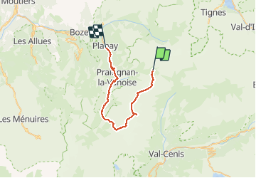

Length
34 km

Max alt
3567 m

Uphill gradient
1288 m
Km-Effort
56 km

Min alt
1160 m

Downhill gradient
2637 m
Boucle
No
Creation date :
2019-05-06 23:16:55.481
Updated on :
2019-05-06 23:16:55.481
8h58
Difficulty : Unknown

FREE GPS app for hiking
 SityTrail
IGN / Geographical institutes
SityTrail Plus
The world is yours!
About
Trail Other activity of 34 km to be discovered at Auvergne-Rhône-Alpes, Savoy, Pralognan-la-Vanoise. This trail is proposed by jfcontour.
Positioning
Country:
France
Region :
Auvergne-Rhône-Alpes
Department/Province :
Savoy
Municipality :
Pralognan-la-Vanoise
Location:
Unknown
Start:(Dec)
Start:(UTM)
327115 ; 5028751 (32T) N.
Comments