


Montandré en circuit

lecmic
User
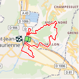

Length
8.8 km

Max alt
884 m

Uphill gradient
404 m
Km-Effort
14.2 km

Min alt
524 m

Downhill gradient
404 m
Boucle
Yes
Creation date :
2019-05-06 23:30:14.081
Updated on :
2019-05-06 23:30:14.081
2h35
Difficulty : Unknown

FREE GPS app for hiking
 SityTrail
IGN / Geographical institutes
SityTrail Plus
The world is yours!
About
Trail Other activity of 8.8 km to be discovered at Auvergne-Rhône-Alpes, Savoy, Saint-Jean-de-Maurienne. This trail is proposed by lecmic.


Positioning
Country:
France
Region :
Auvergne-Rhône-Alpes
Department/Province :
Savoy
Municipality :
Saint-Jean-de-Maurienne
Location:
Unknown
Start:(Dec)
Start:(UTM)
292517 ; 5017001 (32T) N.
Comments