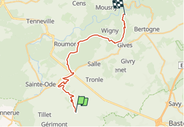
Trail Other activity Sainte-Ode - Rando 1er mai : Etape 2 - Photo

Rando 1er mai : Etape 2

© OpenStreetMap contributors
Length
Length
20 km
Max alt
Max alt
492 m
Uphill gradient
Uphill gradient
470 m
Km-Effort
Km-Effort  
26 km
Min alt
Min alt
320 m
Downhill gradient
Downhill gradient
486 m
Boucle
Boucle
No
Creation date :
10/12/2014 00:00
Updated on :
10/12/2014 00:00

(0 Reviews)

Other activity
Other activity
--
Difficulty : Unknown

Scan this QR Code to open this trail in the SityTrail application

FREE GPS app for hiking

Logo SityTrail SityTrail

IGN / Geographical institutes

Download SityTrail from the App Store Download SityTrail from Google Play

Logo SityTrail SityTrail Plus

The world is yours!

Download SityTrail from the App Store Download SityTrail from Google Play Download SityTrail on Huawei AppGallery

About

Trail Other activity of 20 km to be discovered at Wallonia, Luxembourg, Sainte-Ode. This trail is proposed by kpelosato@hotmail.com.

Elevation profile

Points of interest

Point of interest Sainte-Ode - A vérifier si  chemin - Photo
kpelosato@hotmail.com

Positioning

Country:
Belgium
Region :
Wallonia
Department/Province :
Luxembourg
Municipality :
Sainte-Ode
Location:
Tillet
Start:(UTM)
684268 ; 5543105 (31U) N.


Close
My subscriptions