


2019 04 Freundstein Molkenrain Vieil Armand

staubalex
User
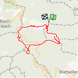

Length
14.6 km

Max alt
1091 m

Uphill gradient
804 m
Km-Effort
25 km

Min alt
475 m

Downhill gradient
805 m
Boucle
Yes
Creation date :
2019-05-07 01:28:57.414
Updated on :
2019-05-07 01:28:57.414
5h08
Difficulty : Difficult

FREE GPS app for hiking
 SityTrail
IGN / Geographical institutes
SityTrail Plus
The world is yours!
About
Trail Walking of 14.6 km to be discovered at Grand Est, Haut-Rhin, Soultz-Haut-Rhin. This trail is proposed by staubalex.
Positioning
Country:
France
Region :
Grand Est
Department/Province :
Haut-Rhin
Municipality :
Soultz-Haut-Rhin
Location:
Unknown
Start:(Dec)
Start:(UTM)
362287 ; 5303884 (32T) N.
Comments