


Angles-sur-l'Anglin - 10.2km 200m 3h00 - 2017 05 21

Orcal37
User GUIDE
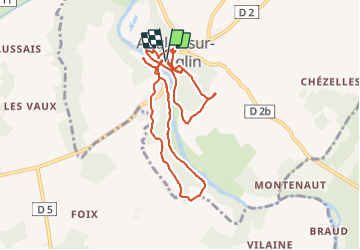

Length
10.2 km

Max alt
126 m

Uphill gradient
191 m
Km-Effort
12.8 km

Min alt
66 m

Downhill gradient
189 m
Boucle
Yes
Creation date :
2019-05-07 01:57:11.221
Updated on :
2021-09-08 10:19:46.989
3h00
Difficulty : Easy

FREE GPS app for hiking
 SityTrail
IGN / Geographical institutes
SityTrail Plus
The world is yours!
About
Trail Walking of 10.2 km to be discovered at New Aquitaine, Vienne, Angles-sur-l'Anglin. This trail is proposed by Orcal37.
Description
Angles-sur-l'Anglin - 10.2km 200m 3h00 - 2017 05 21
Photos

Positioning
Country:
France
Region :
New Aquitaine
Department/Province :
Vienne
Municipality :
Angles-sur-l'Anglin
Location:
Unknown
Start:(Dec)
Start:(UTM)
338144 ; 5173375 (31T) N.
Comments