


Steinbach1

patrickbeyrath
User
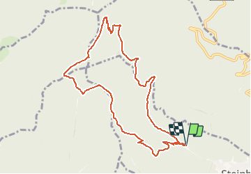

Length
9.7 km

Max alt
897 m

Uphill gradient
513 m
Km-Effort
16.6 km

Min alt
413 m

Downhill gradient
516 m
Boucle
Yes
Creation date :
2018-10-13 05:53:50.122
Updated on :
2018-10-13 05:53:50.13
--
Difficulty : Medium

FREE GPS app for hiking
 SityTrail
IGN / Geographical institutes
SityTrail Plus
The world is yours!
About
Trail Walking of 9.7 km to be discovered at Grand Est, Haut-Rhin, Steinbach. This trail is proposed by patrickbeyrath.
Description
Départ Place de Silberthal parking Piste de quilles-Direction Camp de Turenne-le Glasenberg-le Camps des Pyramides-Rehbrunel-Pasteten Platz-retour croix jaune-Chapelle St Thérèse et Parking d'arrivée
Positioning
Country:
France
Region :
Grand Est
Department/Province :
Haut-Rhin
Municipality :
Steinbach
Location:
Unknown
Start:(Dec)
Start:(UTM)
360678 ; 5298640 (32T) N.
Comments