Trail Walking Savennes - Le chemin des Vergnes - Savennes  - Photo

Le chemin des Vergnes - Savennes

 tracegps
tracegps

User

© OpenStreetMap contributors
Length
Length
8.2 km
Max alt
Max alt
661 m
Uphill gradient
Uphill gradient
246 m
Km-Effort
Km-Effort  
11.5 km
Min alt
Min alt
544 m
Downhill gradient
Downhill gradient
243 m
Boucle
Boucle
Yes
Creation date :
2014-12-10 00:00:00.0
Updated on :
2014-12-10 00:00:00.0

(0 Reviews)

Walking
Walking
2h30
Difficulty : Medium

Scan this QR Code to open this trail in the SityTrail application

FREE GPS app for hiking

Logo SityTrail SityTrail

IGN / Geographical institutes

Download SityTrail from the App Store Download SityTrail from Google Play

Logo SityTrail SityTrail World

The world is yours!

Download SityTrail from the App Store Download SityTrail from Google Play Download SityTrail on Huawei AppGallery

About

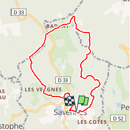
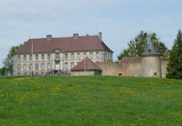
Trail Walking of 8.2 km to be discovered at New Aquitaine, Creuse, Savennes. This trail is proposed by tracegps.

Description

Circuit proposé par l'Office de Tourisme de Guéret. Départ de la place de l'église de Savennes. Retrouvez le circuit et son descriptif sur le site de l'Office de Tourisme de Guéret.

Elevation profile

Photos

Positioning

Country:
France
Region :
New Aquitaine
Department/Province :
Creuse
Municipality :
Savennes
Location:
Unknown
Start:(UTM)
414223 ; 5106373 (31T) N.

Trails nearby

Trail Walking Sainte-Feyre - Les loups de Chabrières - Sainte Feyre - Photo
Walking
tracegps

Walking

Easy
(2)
Sainte-Feyre, New Aquitaine, Creuse, France
6.5 km | 9.5 km-effort
2h 0min
Yes
Trail Nordic walking Sainte-Feyre - Meyrat Perabout Parc à Loups 11.1k - Photo
Nordic walking
yvescousin

Nordic walking

Difficult
(1)
Sainte-Feyre, New Aquitaine, Creuse, France
11.1 km | 15.4 km-effort
2h 30min
Yes
Trail Walking Sainte-Feyre - Pierres et Légendes -  Sainte-Feyre - Photo
Walking
tracegps

Walking

Difficult
Sainte-Feyre, New Aquitaine, Creuse, France
8.5 km | 11.9 km-effort
3h 0min
Yes
Trail Walking Savennes - La Croix de Reillat - Savennes - Photo
Walking
tracegps

Walking

Easy
Savennes, New Aquitaine, Creuse, France
6.7 km | 8.7 km-effort
2h 0min
Yes
Trail Walking La Chapelle-Taillefert - Les cascades de la Rebeyrolle - La Chapelle-Taillefert - Photo
Walking
tracegps

Walking

Very difficult
La Chapelle-Taillefert, New Aquitaine, Creuse, France
15.1 km | 20 km-effort
4h 30min
Yes
Trail Walking Guéret - Chabrières - Guéret - Photo
Walking
tracegps

Walking

Easy
Guéret, New Aquitaine, Creuse, France
6.6 km | 9.1 km-effort
2h 0min
Yes
Trail Walking Sainte-Feyre - Le Puy de Gaudy - Sainte Feyre - Photo
Walking
tracegps

Walking

Easy
Sainte-Feyre, New Aquitaine, Creuse, France
6.8 km | 9.9 km-effort
2h 0min
Yes
Trail Walking La Chapelle-Taillefert - Le Rocher de la Femme Perdue - La Chapelle-Taillefert  - Photo
Walking
tracegps

Walking

Easy
La Chapelle-Taillefert, New Aquitaine, Creuse, France
5.6 km | 7.7 km-effort
1h 25min
Yes
Trail Nordic walking Guéret - sentier rando santé  - Photo
Nordic walking
micheletissier

Nordic walking

Very easy
Guéret, New Aquitaine, Creuse, France
4.6 km | 6.3 km-effort
54min
Yes


Close
My subscriptions