Trail Mountain bike Sigalens - VTT de Sigalens à Grignols - Photo

VTT de Sigalens à Grignols

 tracegps
tracegps

User

© OpenStreetMap contributors
Length
Length
45 km
Max alt
Max alt
166 m
Uphill gradient
Uphill gradient
909 m
Km-Effort
Km-Effort  
57 km
Min alt
Min alt
57 m
Downhill gradient
Downhill gradient
912 m
Boucle
Boucle
Yes
Creation date :
2014-12-10 00:00:00.0
Updated on :
2014-12-10 00:00:00.0

(0 Reviews)

Mountain bike
Mountain bike
3h00
Difficulty : Difficult

Scan this QR Code to open this trail in the SityTrail application

FREE GPS app for hiking

Logo SityTrail SityTrail

IGN / Geographical institutes

Download SityTrail from the App Store Download SityTrail from Google Play

Logo SityTrail SityTrail World

The world is yours!

Download SityTrail from the App Store Download SityTrail from Google Play Download SityTrail on Huawei AppGallery

About

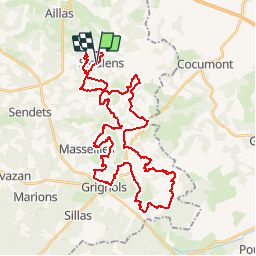
Trail Mountain bike of 45 km to be discovered at New Aquitaine, Gironde, Sigalens. This trail is proposed by tracegps.

Description

Circuit très sympa, bonnes montées et descentes, quelques singles techniques et très peu de route.

Elevation profile

Photos

Positioning

Country:
France
Region :
New Aquitaine
Department/Province :
Gironde
Municipality :
Sigalens
Location:
Unknown
Start:(UTM)
734848 ; 4925865 (30T) N.

Trails nearby

Trail On foot Romestaing - Romestaing, dans les pas des Templiers - 8.3 km - Photo
On foot
PRO

On foot

Easy
Romestaing, New Aquitaine, Lot-et-Garonne, France
8.2 km | 11.1 km-effort
2h 30min
Yes
Trail Walking Sigalens - tour du lac de Sigalens - Photo
Walking
sandrineh

Walking

Very easy
Sigalens, New Aquitaine, Gironde, France
4.2 km | 5 km-effort
1h 30min
Yes
Trail Mountain bike Saint-Sauveur-de-Meilhan - Saint Sauveur de Meilhan, porte de la Gironde - Pays Val de Garonne - Gascogne - Photo
Mountain bike
tracegps

Mountain bike

Medium
Saint-Sauveur-de-Meilhan, New Aquitaine, Lot-et-Garonne, France
6.2 km | 8.5 km-effort
45min
Yes
Trail Walking Saint-Sauveur-de-Meilhan - Saint Sauveur de Meilhan, porte de la Gironde - Pays Val de Garonne - Gascogne - Photo
Walking
tracegps

Walking

Medium
Saint-Sauveur-de-Meilhan, New Aquitaine, Lot-et-Garonne, France
6.2 km | 8.5 km-effort
2h 15min
Yes
Trail Walking Aillas - La route de la Transhumance - Photo
Walking
Elbe

Walking

Easy
Aillas, New Aquitaine, Gironde, France
14.8 km | 17.7 km-effort
3h 47min
Yes


Close
My subscriptions