Trail Walking Mazamet - Mazamet - Hautpoul - Photo

Mazamet - Hautpoul

 tracegps
tracegps

User

© OpenStreetMap contributors
Length
Length
17.4 km
Max alt
Max alt
651 m
Uphill gradient
Uphill gradient
840 m
Km-Effort
Km-Effort  
29 km
Min alt
Min alt
255 m
Downhill gradient
Downhill gradient
837 m
Boucle
Boucle
Yes
Creation date :
2014-12-10 00:00:00.0
Updated on :
2014-12-10 00:00:00.0

(1 Reviews)

Walking
Walking
6h30
Difficulty : Difficult

Scan this QR Code to open this trail in the SityTrail application

FREE GPS app for hiking

Logo SityTrail SityTrail

IGN / Geographical institutes

Download SityTrail from the App Store Download SityTrail from Google Play

Logo SityTrail SityTrail World

The world is yours!

Download SityTrail from the App Store Download SityTrail from Google Play Download SityTrail on Huawei AppGallery

About

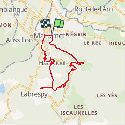
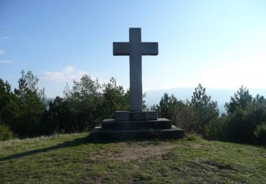
Trail Walking of 17.4 km to be discovered at Occitania, Tarn, Mazamet. This trail is proposed by tracegps.

Description

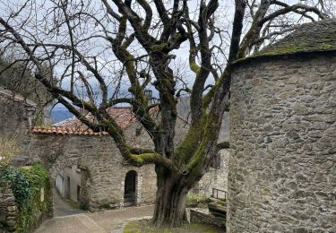
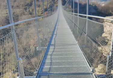
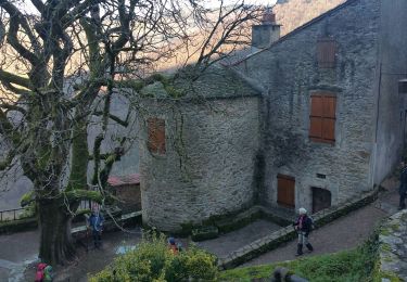
Au fil de l'eau - Sentiers de l'Arnette industrielle. Le sentier de randonnée « Au fil de l’eau », propose aux randonneurs de découvrir, pas à pas, l’histoire industrielle de la vallée de l’Arnette. Cette boucle sillonnant au cœur d’un superbe paysage est une invitation à remonter le temps et à s’initier à cette épopée industrielle qui a fait la réputation de Mazamet à travers le monde. En suivant l’Arnette, tantôt apaisée, tantôt tumultueuse, le randonneur suivra les traces de cette aventure originale, dont l’apogée se situe au XIXè siècle, lorsque le délainage s’est imposé comme moteur d’un extraordinaire développement économique et social. Si l’histoire locale reste encore fortement ancrée dans l’esprit des mazamétains, il était important, pour les générations futures comme pour les touristes qui sont de plus en plus nombreux à nous rendre visite, de préserver la mémoire de la ville et de relier d’un fil conducteur les sites les plus marquants. La suite est dans ce dossier, ...et aussi l'Office de Tourisme de Mazamet. Départ du parking du Champ de la ville à Mazamet... Le circuit est très bien indiqué et parfaitement fléché.

Elevation profile

Photos

Points of interest

Point of interest Mazamet - 001-Parking Mazamet - Photo
tracegps
Point of interest Mazamet - 002-On monte - Photo
tracegps
MAZAMET 
Point of interest Mazamet - 005-Usine - Photo
tracegps
MAZAMET 
Point of interest Mazamet - 006-Jardin Cormouls - Photo
tracegps
Point of interest Mazamet - 007-Citadelle - Photo
tracegps
MAZAMET 
Point of interest Mazamet - 008-L'Arnette - Photo
tracegps
MAZAMET 
Point of interest Mazamet - 009-Hautpoul - Photo
tracegps
MAZAMET 
Point of interest Mazamet - 010-Fortification - Photo
tracegps
Point of interest Mazamet - 011-Croix cathare - Photo
tracegps
Point of interest Mazamet - 012-Vierge - Photo
tracegps
MAZAMET 
Point of interest Mazamet - 013-Halte repas - Photo
tracegps
Point of interest Mazamet - 015-Ferme de Brettes - Photo
tracegps
Point of interest Mazamet - 016-Croix de Prat - Photo
tracegps

Positioning

Country:
France
Region :
Occitania
Department/Province :
Tarn
Municipality :
Mazamet
Location:
Unknown
Start:(UTM)
449777 ; 4815488 (31T) N.

Comments

Please log in to post a review or rate the element


Belle petite randonné au départ de l'office du tourisme de Mazamet


Trails nearby

Trail Walking Mazamet - Maeamet la passerelle - Photo
Walking
ombrabella

Walking

Medium
Mazamet, Occitania, Tarn, France
4.5 km | 8.6 km-effort
1h 32min
Yes
Trail Walking Mazamet - Passerelle de Mazamet et village médiéval d'Hautpoul - Photo
Walking
Dominique48

Walking

Difficult
Mazamet, Occitania, Tarn, France
3.2 km | 6.9 km-effort
1h 41min
Yes
Trail Mountain bike Aussillon - Montagne Noire -  Les Montagnès - 6754 - UtagawaVTT.com - Photo
Mountain bike
guillaumepdm

Mountain bike

Difficult
(1)
Aussillon, Occitania, Tarn, France
29 km | 41 km-effort
2h 49min
Yes
Trail Walking Mazamet - depuis HAUPOULet  en 2 boucles - Photo
Walking
chrisgps

Walking

Very easy
Mazamet, Occitania, Tarn, France
14.2 km | 23 km-effort
6h 6min
Yes
Trail Walking Mazamet - Labrespy, Hautpoul, St-Pierre des Plots - Photo
Walking
Jean-Phi81

Walking

Medium
(1)
Mazamet, Occitania, Tarn, France
9 km | 13.8 km-effort
3h 1min
Yes
Trail Walking Mazamet - Labrespy - la Croix de Prat - Photo
Walking
Jean-Phi81

Walking

Medium
(1)
Mazamet, Occitania, Tarn, France
13.8 km | 21 km-effort
4h 35min
Yes
Trail Mountain bike Aiguefonde - Balade sur le Causse - Saint Alby    - Photo
Mountain bike
tracegps

Mountain bike

Medium
Aiguefonde, Occitania, Tarn, France
29 km | 37 km-effort
3h 0min
Yes
Trail Mountain bike Aiguefonde - Les cinq croix - Saint Alby - Photo
Mountain bike
tracegps

Mountain bike

Difficult
Aiguefonde, Occitania, Tarn, France
38 km | 52 km-effort
4h 0min
Yes
Trail Walking Aiguefonde - AIGUEFONDE Les Fermes - Photo
Walking
miqueljp

Walking

Medium
(1)
Aiguefonde, Occitania, Tarn, France
11.6 km | 17.9 km-effort
3h 50min
Yes


Close
My subscriptions