Trail Cycle Bollène - Circuit Vélo -  Tour du Massif d'Uchaux - Bollène - Photo

Circuit Vélo - Tour du Massif d'Uchaux - Bollène

 tracegps
tracegps

User

© OpenStreetMap contributors
Length
Length
43 km
Max alt
Max alt
172 m
Uphill gradient
Uphill gradient
515 m
Km-Effort
Km-Effort  
49 km
Min alt
Min alt
37 m
Downhill gradient
Downhill gradient
523 m
Boucle
Boucle
Yes
Creation date :
2014-12-10 00:00:00.0
Updated on :
2014-12-10 00:00:00.0

(1 Reviews)

Cycle
Cycle
4h30
Difficulty : Difficult

Scan this QR Code to open this trail in the SityTrail application

FREE GPS app for hiking

Logo SityTrail SityTrail

IGN / Geographical institutes

Download SityTrail from the App Store Download SityTrail from Google Play

Logo SityTrail SityTrail World

The world is yours!

Download SityTrail from the App Store Download SityTrail from Google Play Download SityTrail on Huawei AppGallery

About

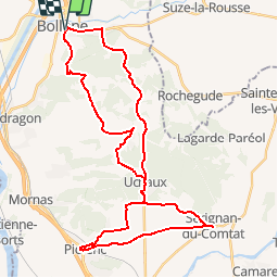
Trail Cycle of 43 km to be discovered at Provence-Alpes-Côte d'Azur, Vaucluse, Bollène. This trail is proposed by tracegps.

Description

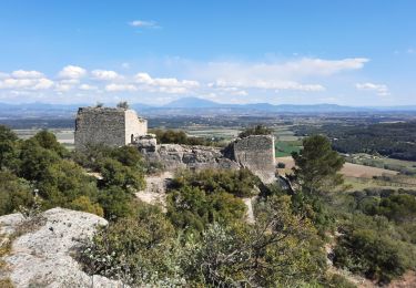
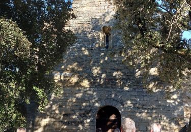
Un parcours d’une grande diversité tant au niveau des paysages que du patrimoine bâti mais également du dénivelé ! A aucun moment la monotonie ne s’installe lors de cette randonnée : après la visite de la ville de Bollène, riche d’un patrimoine historique et naturel remarquable, le parcours vous mènera en forêt jusqu’à Uchaux. Entre Piolenc et Sérignan du Comtat c’est au milieu du vignoble que vous progresserez. La visite de ces 2 communes vous donnera un aperçu de l’art de vivre en Provence. Le retour sur Bollène se fera entre vigne et forêt. Départ de la Collégiale Saint Martin à Bollène. Retrouvez plus d’informations et téléchargez la fiche du circuit sur le site de la Provence en vélo.

Elevation profile

Photos

Positioning

Country:
France
Region :
Provence-Alpes-Côte d'Azur
Department/Province :
Vaucluse
Municipality :
Bollène
Location:
Unknown
Start:(UTM)
639745 ; 4904311 (31T) N.

Comments

Please log in to post a review or rate the element


a faire


Trails nearby

Trail Walking Bollène - Barry Chabrières Enclume 7,5km - Photo
Walking
GUIDE
thonyc

Walking

Medium
(1)
Bollène, Provence-Alpes-Côte d'Azur, Vaucluse, France
7.6 km | 10.1 km-effort
2h 30min
Yes
Trail Walking Mondragon - mondragon  - Photo
Walking
Cricounet84

Walking

Easy
(1)
Mondragon, Provence-Alpes-Côte d'Azur, Vaucluse, France
8.3 km | 9.4 km-effort
2h 4min
Yes
Trail Walking Mondragon - Mondragon -Mornas - Photo
Walking
ALAPETITE

Walking

Very easy
(1)
Mondragon, Provence-Alpes-Côte d'Azur, Vaucluse, France
16.3 km | 21 km-effort
4h 28min
Yes
Trail Walking Bollène - Chabrieres  - Photo
Walking
Perdrizet Pascal

Walking

Medium
Bollène, Provence-Alpes-Côte d'Azur, Vaucluse, France
5.2 km | 8.2 km-effort
2h 0min
Yes
Trail Walking Bollène - SityTrail - RS Barry Chabrières 7,5km - Photo
Walking
GUIDE
thonyc

Walking

Medium
Bollène, Provence-Alpes-Côte d'Azur, Vaucluse, France
7.4 km | 9.8 km-effort
2h 30min
Yes
Trail On foot Bollène - 84 mines et grottes de st blaise bollene sans 3eme chapelle - Photo
On foot
himba26100

On foot

Medium
Bollène, Provence-Alpes-Côte d'Azur, Vaucluse, France
16.6 km | 21 km-effort
4h 52min
Yes
Trail Walking Bollène - 84 mines et grottes de st blaise bollene - Photo
Walking
himba26100

Walking

Medium
Bollène, Provence-Alpes-Côte d'Azur, Vaucluse, France
18.1 km | 24 km-effort
6h 38min
Yes
Trail Mountain bike Suze-la-Rousse - Bollene - Le Lez - Photo
Mountain bike
tracegps

Mountain bike

Difficult
(1)
Suze-la-Rousse, Auvergne-Rhône-Alpes, Drôme, France
24 km | 31 km-effort
2h 0min
Yes
Trail Walking Bollène - les chapelles st Blaise st Pierre RLD - Photo
Walking
gilchan

Walking

Easy
Bollène, Provence-Alpes-Côte d'Azur, Vaucluse, France
11.3 km | 14.3 km-effort
2h 50min
Yes


Close
My subscriptions