Trail Walking Mons - Le Montahut et Saint Martin du Froid - Photo

Le Montahut et Saint Martin du Froid

 tracegps
tracegps

User

© OpenStreetMap contributors
Length
Length
17.8 km
Max alt
Max alt
1074 m
Uphill gradient
Uphill gradient
785 m
Km-Effort
Km-Effort  
28 km
Min alt
Min alt
443 m
Downhill gradient
Downhill gradient
783 m
Boucle
Boucle
Yes
Creation date :
2014-12-10 00:00:00.0
Updated on :
2014-12-10 00:00:00.0

(0 Reviews)

Walking
Walking
6h30
Difficulty : Difficult

Scan this QR Code to open this trail in the SityTrail application

FREE GPS app for hiking

Logo SityTrail SityTrail

IGN / Geographical institutes

Download SityTrail from the App Store Download SityTrail from Google Play

Logo SityTrail SityTrail World

The world is yours!

Download SityTrail from the App Store Download SityTrail from Google Play Download SityTrail on Huawei AppGallery

About

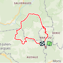
Trail Walking of 17.8 km to be discovered at Occitania, Hérault, Mons. This trail is proposed by tracegps.

Description

Massif du Caroux - Le Montahut et Saint-Martin du Froid. Rando organisé par Jacques de Mazamet. Après Saint-Pons, prendre la direction de Lamalou-les-Bains sur la D908 puis après Olargues prendre sur la gauche direction Bardou. Une petite route nous amène après quelques km sur les bords du lac d'Airette ou l'on peut aisément se garer. On prend tout de suite le GR7 bien fléché. On monte le long d'un sentier qui traverse un très beau paysage. D'abord le village en ruines de Chavardès avec son four à pain, puis plus haut on va contourner le Montahut avant de filer sur le plateau à plus de 1000m d'altitude vers la maison forestière des Bourdils où l'on va faire la pause repas sous un très beau soleil (on est mi-mars). On quitte le GR7 pour prendre le GR71 sur le plateau de la réserve de Lespinouse toujours à 1040m d'altitude. On quitte le GR71 en direction de la chapelle de Saint-Martin du Froid sur un chemin roulable. A la chapelle on prend une piste étroite mais bien pavée qui va descendre sur le hameau de Bardou et de là on rejoint le lac d'Airette.

Elevation profile

Photos

Points of interest

Point of interest Riols - 000-Parking RDV Riols - Photo
tracegps
Point of interest Mons - 001-Lac d'Airette - Photo
tracegps
Point of interest Saint-Julien - 003-La grande montée - Photo
tracegps
SAINT-JULIEN 
Point of interest Cambon-et-Salvergues - 005-Ruines village - Photo
tracegps
CAMBON-ET-SALVERGUES 
Point of interest Saint-Julien - 007-Sentier pierreux - Photo
tracegps
SAINT-JULIEN 
Point of interest Saint-Julien - 008-Le Montahut - Photo
tracegps
SAINT-JULIEN 
Point of interest Saint-Julien - 009-Maison forestière des Bourdils - Photo
tracegps
Point of interest Saint-Julien - 010-Reserve du Caroux - Photo
tracegps
SAINT-JULIEN 
Point of interest Cambon-et-Salvergues - 012-La Peyroutarie - Photo
tracegps
CAMBON-ET-SALVERGUES 
Point of interest Cambon-et-Salvergues - 013-Chapelle de St-Martin du Froid - Photo
tracegps
CAMBON-ET-SALVERGUES 
Point of interest Mons - 018-Bardou - Photo
tracegps

Positioning

Country:
France
Region :
Occitania
Department/Province :
Hérault
Municipality :
Mons
Location:
Unknown
Start:(UTM)
495232 ; 4825615 (31T) N.

Trails nearby

Trail Walking Rosis - Petit tour du plateau du Caroux  - Photo
Walking
tracegps

Walking

Medium
(2)
Rosis, Occitania, Hérault, France
7.8 km | 11.2 km-effort
2h 30min
Yes
Trail Walking Mons - Le sentier des Gardes / Douch / Héric  - Photo
Walking
germain24

Walking

Very difficult
(1)
Mons, Occitania, Hérault, France
15.2 km | 28 km-effort
6h 22min
Yes
Trail Walking Olargues - Trois jours autour d'Olargues.  - Photo
Walking
GUIDE
nadinebondoux

Walking

Difficult
Olargues, Occitania, Hérault, France
25 km | 36 km-effort
7h 45min
No
Trail On foot Rosis - Le Vialaïs - Photo
On foot
PRO

On foot

Easy
Rosis, Occitania, Hérault, France
8.4 km | 15.7 km-effort
3h 33min
No
Trail Walking Mons - Piste des aiguilles - Photo
Walking
gerardhenr

Walking

Very difficult
(1)
Mons, Occitania, Hérault, France
5.6 km | 13.9 km-effort
3h 2min
No
Trail Walking Saint-Martin-de-l'Arçon - Piste des triangles Bertouyre - Photo
Walking
jdelettrez

Walking

Difficult
(1)
Saint-Martin-de-l'Arçon, Occitania, Hérault, France
7.1 km | 15 km-effort
3h 2min
Yes
Trail Walking Saint-Martin-de-l'Arçon - Saint-Martin de larçon - Photo
Walking
yt34

Walking

Easy
(2)
Saint-Martin-de-l'Arçon, Occitania, Hérault, France
6.3 km | 13.2 km-effort
2h 41min
Yes
Trail Walking Olargues - Olargues Malvies  - Photo
Walking
miqueljp

Walking

Medium
(2)
Olargues, Occitania, Hérault, France
15.5 km | 23 km-effort
5h 9min
Yes
Trail Walking Saint-Martin-de-l'Arçon - ballade au Caroux, le long de l'orbe et dans les hameaux du piémont.  - Photo
Walking
jeff2

Walking

Easy
Saint-Martin-de-l'Arçon, Occitania, Hérault, France
11.3 km | 16.2 km-effort
4h 5min
Yes


Close
My subscriptions