Trail Running Beaucroissant - Sacré Trail des Collines - Col de Parménie - Photo

Sacré Trail des Collines - Col de Parménie

 tracegps
tracegps

User

© OpenStreetMap contributors
Length
Length
35 km
Max alt
Max alt
783 m
Uphill gradient
Uphill gradient
1645 m
Km-Effort
Km-Effort  
57 km
Min alt
Min alt
489 m
Downhill gradient
Downhill gradient
1666 m
Boucle
Boucle
Yes
Creation date :
2014-12-10 00:00:00.0
Updated on :
2014-12-10 00:00:00.0

(0 Reviews)

Running
Running
4h00
Difficulty : Difficult

Scan this QR Code to open this trail in the SityTrail application

FREE GPS app for hiking

Logo SityTrail SityTrail

IGN / Geographical institutes

Download SityTrail from the App Store Download SityTrail from Google Play

Logo SityTrail SityTrail World

The world is yours!

Download SityTrail from the App Store Download SityTrail from Google Play Download SityTrail on Huawei AppGallery

About

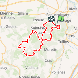
Trail Running of 35 km to be discovered at Auvergne-Rhône-Alpes, Isère, Beaucroissant. This trail is proposed by tracegps.

Description

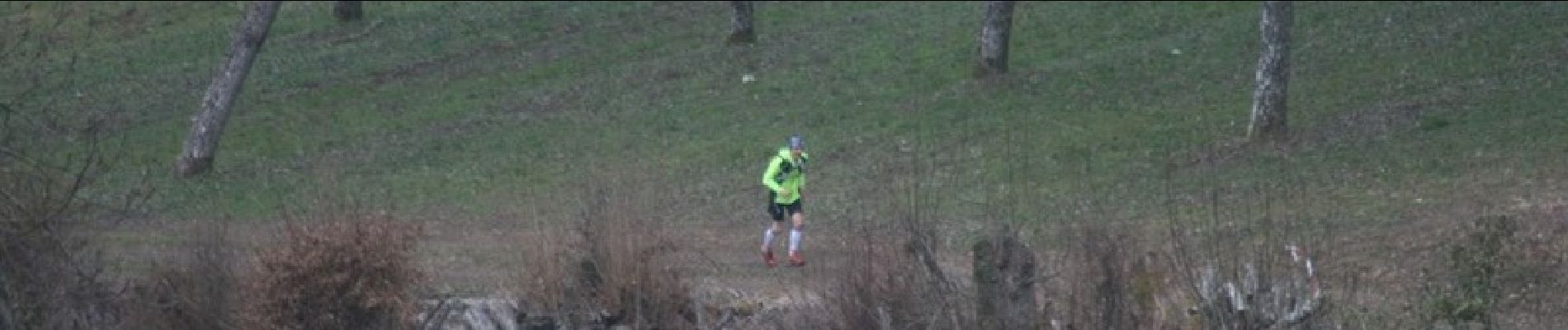
Ce jour 1er trail de préparation à la Maxi Race, il se passe entre Izeaux et Tullins au col de Parménie. Il porte bien son nom : température 1.5°, vent glacial sur les plateaux, pluie froide après 1h40', neige dans la dernière heure, terrain boueux, ruisselant, passage dans des terrains privés. Ce trail est un excellent entrainement car il roule bien sur terrain sec, les ascensions sont raides dont deux très difficiles sur la fin. Pour réussir ces ascensions dans une pente vertigineuse et sur un terrain glissant il fallait se tenir avec les arbres ou taillis pour ne pas glisser. A l'arrivée j'étais congelé, je ne pouvais plus répondre au GSM...

Elevation profile

Photos

Positioning

Country:
France
Region :
Auvergne-Rhône-Alpes
Department/Province :
Isère
Municipality :
Beaucroissant
Location:
Unknown
Start:(UTM)
693398 ; 5021883 (31T) N.

Trails nearby

Trail Walking Beaucroissant - Beaucroissant-Galaboutemps - Photo
Walking
raymondfn

Walking

Medium
(1)
Beaucroissant, Auvergne-Rhône-Alpes, Isère, France
7.2 km | 7.6 km-effort
1h 33min
Yes
Trail Walking Tullins - Clos des Chartreux Parmenie 2 - Photo
Walking
micoud

Walking

Medium
Tullins, Auvergne-Rhône-Alpes, Isère, France
14.1 km | 23 km-effort
5h 29min
Yes
Trail Walking Rives - Anniv Do - Photo
Walking
bourdevos

Walking

Medium
Rives, Auvergne-Rhône-Alpes, Isère, France
7.8 km | 9.8 km-effort
2h 12min
Yes
Trail Walking Beaucroissant - Beaucroissant - Photo
Walking
lilloue

Walking

Medium
Beaucroissant, Auvergne-Rhône-Alpes, Isère, France
7.5 km | 8 km-effort
3h 4min
Yes
Trail Walking Izeaux - Izeaux-le tour des carrières - Photo
Walking
raymondfn

Walking

Easy
Izeaux, Auvergne-Rhône-Alpes, Isère, France
5.4 km | 5.9 km-effort
1h 20min
Yes
Trail Mountain bike Tullins - VTT châtain 2 - Photo
Mountain bike
lolo38

Mountain bike

Difficult
Tullins, Auvergne-Rhône-Alpes, Isère, France
23 km | 32 km-effort
3h 2min
Yes
Trail Mountain bike Tullins - VTT esinar  - Photo
Mountain bike
lolo38

Mountain bike

Medium
Tullins, Auvergne-Rhône-Alpes, Isère, France
26 km | 37 km-effort
1h 58min
No
Trail Walking Rives - rando rives - Photo
Walking
lilloue

Walking

Very easy
Rives, Auvergne-Rhône-Alpes, Isère, France
6 km | 7.5 km-effort
2h 28min
Yes
Trail Walking Rives - rives - Photo
Walking
lilloue

Walking

Very easy
Rives, Auvergne-Rhône-Alpes, Isère, France
5.7 km | 7.2 km-effort
1h 36min
Yes


Close
My subscriptions