Trail Mountain bike Riom -  Les 2 vallées autour de Châtel Guyon - Photo

Les 2 vallées autour de Châtel Guyon

 tracegps
tracegps

User

© OpenStreetMap contributors
Length
Length
29 km
Max alt
Max alt
510 m
Uphill gradient
Uphill gradient
434 m
Km-Effort
Km-Effort  
34 km
Min alt
Min alt
323 m
Downhill gradient
Downhill gradient
432 m
Boucle
Boucle
Yes
Creation date :
2014-12-10 00:00:00.0
Updated on :
2014-12-10 00:00:00.0

(0 Reviews)

Mountain bike
Mountain bike
2h15
Difficulty : Difficult

Scan this QR Code to open this trail in the SityTrail application

FREE GPS app for hiking

Logo SityTrail SityTrail

IGN / Geographical institutes

Download SityTrail from the App Store Download SityTrail from Google Play

Logo SityTrail SityTrail World

The world is yours!

Download SityTrail from the App Store Download SityTrail from Google Play Download SityTrail on Huawei AppGallery

About

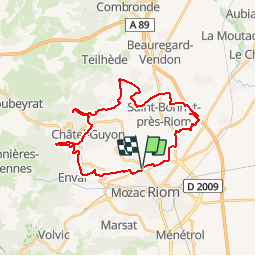
Trail Mountain bike of 29 km to be discovered at Auvergne-Rhône-Alpes, Puy-de-Dôme, Riom. This trail is proposed by tracegps.

Description

Départ de la chapelle St Don à Riom, ou vallée de Sans Souci et salle des fêtes à Châtelguyon. Rando avec quelques grimpettes. A faire par beau temps. Attention en traversant les routes.

Elevation profile

Photos

Positioning

Country:
France
Region :
Auvergne-Rhône-Alpes
Department/Province :
Puy-de-Dôme
Municipality :
Riom
Location:
Unknown
Start:(UTM)
507703 ; 5083432 (31T) N.

Trails nearby

Trail On foot Loubeyrat - La Vallee des Prades - Photo
On foot
PRO

On foot

Easy
(1)
Loubeyrat, Auvergne-Rhône-Alpes, Puy-de-Dôme, France
11.1 km | 15.6 km-effort
3h 33min
Yes
Trail Walking Enval - Enval_Gorges - Photo
Walking
GUIDE
jagarnier

Walking

Medium
(1)
Enval, Auvergne-Rhône-Alpes, Puy-de-Dôme, France
9.1 km | 13.2 km-effort
2h 45min
Yes
Trail Walking Loubeyrat - Le roc du diable - Prompsat - Photo
Walking
Gegetop

Walking

Medium
(1)
Loubeyrat, Auvergne-Rhône-Alpes, Puy-de-Dôme, France
9.5 km | 13.4 km-effort
2h 20min
Yes
Trail Walking Gimeaux - Chemin de Fontête - Photo
Walking
Gegetop

Walking

Easy
(2)
Gimeaux, Auvergne-Rhône-Alpes, Puy-de-Dôme, France
8.6 km | 11.9 km-effort
2h 6min
Yes
Trail Walking Châtel-Guyon - Les Briffons-Bois d'Agnat - Photo
Walking
Gegetop

Walking

Easy
(2)
Châtel-Guyon, Auvergne-Rhône-Alpes, Puy-de-Dôme, France
10.6 km | 14.8 km-effort
3h 14min
Yes
Trail Walking Châtel-Guyon - Chazeron sans souci - Photo
Walking
Gegetop

Walking

Easy
(1)
Châtel-Guyon, Auvergne-Rhône-Alpes, Puy-de-Dôme, France
6.6 km | 9.7 km-effort
1h 45min
Yes
Trail Walking Châtel-Guyon - Boucle de Rochepradière en passant par Douhady - Photo
Walking
Gegetop

Walking

Easy
(1)
Châtel-Guyon, Auvergne-Rhône-Alpes, Puy-de-Dôme, France
6.7 km | 9.7 km-effort
2h 6min
Yes
Trail Walking Châtel-Guyon - Le tour de Montaclier - Saint Hippolyte - Photo
Walking
tracegps

Walking

Difficult
(1)
Châtel-Guyon, Auvergne-Rhône-Alpes, Puy-de-Dôme, France
14 km | 19.6 km-effort
3h 30min
Yes
Trail On foot Châtel-Guyon - La Vallée du Sans-Souci - Photo
On foot
PRO

On foot

Easy
Châtel-Guyon, Auvergne-Rhône-Alpes, Puy-de-Dôme, France
4.4 km | 6.5 km-effort
1h 28min
Yes


Close
My subscriptions