


demi saint Arnaud - pont du casse

mapomme
User
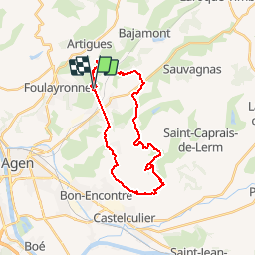

Length
27 km

Max alt
182 m

Uphill gradient
754 m
Km-Effort
37 km

Min alt
60 m

Downhill gradient
754 m
Boucle
Yes
Creation date :
2014-12-10 00:00:00.0
Updated on :
2014-12-10 00:00:00.0
3h36
Difficulty : Easy

FREE GPS app for hiking
 SityTrail
IGN / Geographical institutes
SityTrail Plus
The world is yours!
About
Trail Mountain bike of 27 km to be discovered at New Aquitaine, Lot-et-Garonne, Pont-du-Casse. This trail is proposed by mapomme.
Positioning
Country:
France
Region :
New Aquitaine
Department/Province :
Lot-et-Garonne
Municipality :
Pont-du-Casse
Location:
Unknown
Start:(Dec)
Start:(UTM)
313971 ; 4900943 (31T) N.
Comments