


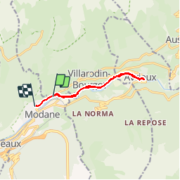
modane avrieux AR

Vincentetourmy
User

Length
9.2 km

Max alt
1131 m

Uphill gradient
143 m
Km-Effort
11.2 km

Min alt
1067 m

Downhill gradient
165 m
Boucle
No
Creation date :
2014-12-10 00:00:00.0
Updated on :
2014-12-10 00:00:00.0
48m
Difficulty : Easy

FREE GPS app for hiking
 SityTrail
IGN / Geographical institutes
SityTrail Plus
The world is yours!
About
Trail Running of 9.2 km to be discovered at Auvergne-Rhône-Alpes, Savoy, Villarodin-Bourget. This trail is proposed by Vincentetourmy.
Description
Parcours footing plat ou quasi plat autour de modane
Positioning
Country:
France
Region :
Auvergne-Rhône-Alpes
Department/Province :
Savoy
Municipality :
Villarodin-Bourget
Location:
Unknown
Start:(Dec)
Start:(UTM)
317693 ; 5008638 (32T) N.
Comments