


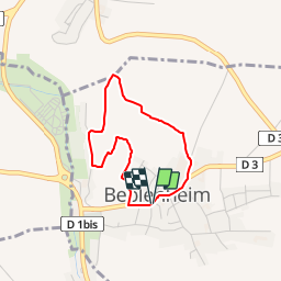
Sentier d'interprétation Beblenheim

Schnacka
User


44m
Difficulty : Easy

FREE GPS app for hiking
 SityTrail
IGN / Geographical institutes
SityTrail Plus
The world is yours!
About
Trail Walking of 2.6 km to be discovered at Grand Est, Haut-Rhin, Beblenheim. This trail is proposed by Schnacka.
Description
Sentier d'interprétation à travers le vignoble de Beblenheim.
Partez à la découverte d'un milieu naturel riche, dans lequel s'épanouit la vigne façonnée par l'homme et l'histoire.
Découvrez Jean Macé, Chrétien Oberlin et le Château des Barons de Hoen devenu la cave vinicole de Beblenheim.


Positioning
Comments