


Chalampe relax

glbs
User
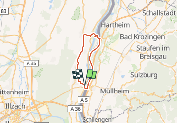

Length
31 km

Max alt
223 m

Uphill gradient
196 m
Km-Effort
34 km

Min alt
194 m

Downhill gradient
196 m
Boucle
Yes
Creation date :
2014-12-10 00:00:00.0
Updated on :
2014-12-10 00:00:00.0
2h11
Difficulty : Unknown

FREE GPS app for hiking
 SityTrail
IGN / Geographical institutes
SityTrail Plus
The world is yours!
About
Trail Mountain bike of 31 km to be discovered at Grand Est, Haut-Rhin, Chalampé. This trail is proposed by glbs.
Positioning
Country:
France
Region :
Grand Est
Department/Province :
Haut-Rhin
Municipality :
Chalampé
Location:
Unknown
Start:(Dec)
Start:(UTM)
390868 ; 5297462 (32T) N.
Comments