Trail Walking Bouillac - Bouillac-Grand Selve - Photo

Bouillac-Grand Selve

 houbart
houbart

User

© OpenStreetMap contributors
Length
Length
12.5 km
Max alt
Max alt
213 m
Uphill gradient
Uphill gradient
223 m
Km-Effort
Km-Effort  
15.5 km
Min alt
Min alt
138 m
Downhill gradient
Downhill gradient
221 m
Boucle
Boucle
Yes
Creation date :
2014-12-10 00:00:00.0
Updated on :
2014-12-10 00:00:00.0

(0 Reviews)

Walking
Walking
3h00
Difficulty : Easy

Scan this QR Code to open this trail in the SityTrail application

FREE GPS app for hiking

Logo SityTrail SityTrail

IGN / Geographical institutes

Download SityTrail from the App Store Download SityTrail from Google Play

Logo SityTrail SityTrail World

The world is yours!

Download SityTrail from the App Store Download SityTrail from Google Play Download SityTrail on Huawei AppGallery

About

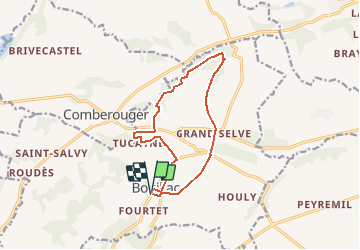
Trail Walking of 12.5 km to be discovered at Occitania, Tarn-et-Garonne, Bouillac. This trail is proposed by houbart.

Description

Départ à l'angle des D55 et 55bis. Descendre vers Beaupuy.
(Pas de marquage au début de la rando.)
A l'entrée de la forêt, 2 possibilités : soit suivre les marquages jaunes soit prendre à droite le chemin qui traverse la forêt.

Elevation profile

Positioning

Country:
France
Region :
Occitania
Department/Province :
Tarn-et-Garonne
Municipality :
Bouillac
Location:
Unknown
Start:(UTM)
348745 ; 4856035 (31T) N.

Trails nearby

Trail Mountain bike Savenès - VTT burgaud  - Photo
Mountain bike
djay82

Mountain bike

Difficult
Savenès, Occitania, Tarn-et-Garonne, France
30 km | 36 km-effort
2h 27min
Yes


Close
My subscriptions