Trail Mountain bike Montendre - Randonnée Montendre 2012 - Photo

Randonnée Montendre 2012

 tracegps
tracegps

User

© OpenStreetMap contributors
Length
Length
39 km
Max alt
Max alt
124 m
Uphill gradient
Uphill gradient
395 m
Km-Effort
Km-Effort  
44 km
Min alt
Min alt
62 m
Downhill gradient
Downhill gradient
393 m
Boucle
Boucle
Yes
Creation date :
2014-12-10 00:00:00.0
Updated on :
2014-12-10 00:00:00.0

(0 Reviews)

Mountain bike
Mountain bike
2h30
Difficulty : Medium

Scan this QR Code to open this trail in the SityTrail application

FREE GPS app for hiking

Logo SityTrail SityTrail

IGN / Geographical institutes

Download SityTrail from the App Store Download SityTrail from Google Play

Logo SityTrail SityTrail World

The world is yours!

Download SityTrail from the App Store Download SityTrail from Google Play Download SityTrail on Huawei AppGallery

About

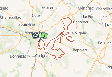
Trail Mountain bike of 39 km to be discovered at New Aquitaine, Charente-Maritime, Montendre. This trail is proposed by tracegps.

Description

Circuit de 40km enregistré lors de la randonnée FFCT organisée par le club local "Randonneurs de La Livenne", le dimanche 25 mars 2012. Il s'agit d'un circuit plutôt roulant. La 1ère boucle au Sud (les 2/3 du circuit) se déroule essentiellement sur des pistes forestières et quelques passages étroits. La 2ème boucle au Nord présente davantage de dénivelée. Le circuit peut être écourté avant le bourg de Jussas. Ce parcours nous fait profiter de la richesse naturelle de la Haute-Saintonge et de la Forêt de la Double, composée en grande partie de pins maritimes. Les amoureux de la faune pourront surprendre des sangliers, des chevreuils, des couleuvres vipérines… Bonne randonnée !

Elevation profile

Photos

Positioning

Country:
France
Region :
New Aquitaine
Department/Province :
Charente-Maritime
Municipality :
Montendre
Location:
Unknown
Start:(UTM)
704315 ; 5016247 (30T) N.

Trails nearby

Trail Mountain bike Montendre - montendre , chepniers - Photo
Mountain bike
flo65

Mountain bike

Very difficult
Montendre, New Aquitaine, Charente-Maritime, France
40 km | 45 km-effort
4h 23min
No
Trail Walking Montendre - Croix Gente 10 km - Photo
Walking
JACQUOU

Walking

Easy
Montendre, New Aquitaine, Charente-Maritime, France
9.5 km | 11 km-effort
2h 29min
No
Trail Walking Montendre - Croix Gente  12 km  - Photo
Walking
JACQUOU

Walking

Easy
Montendre, New Aquitaine, Charente-Maritime, France
11.6 km | 13.2 km-effort
3h 0min
Yes
Trail Walking Donnezac - Donnezac V2 - Photo
Walking
Rosko65

Walking

Easy
Donnezac, New Aquitaine, Gironde, France
18.5 km | 20 km-effort
4h 31min
Yes
Trail Walking Montendre - Caprando 17 Montendre  - Photo
Walking
0220599652

Walking

Very easy
Montendre, New Aquitaine, Charente-Maritime, France
11.3 km | 12.3 km-effort
2h 46min
Yes
Trail Nordic walking Montendre - marche nordique montendre - Photo
Nordic walking
0220599652

Nordic walking

Easy
Montendre, New Aquitaine, Charente-Maritime, France
5.8 km | 6.2 km-effort
1h 39min
Yes
Trail Walking Montendre - Montendre  - Photo
Walking
JACQUOU

Walking

Difficult
Montendre, New Aquitaine, Charente-Maritime, France
12.2 km | 13.2 km-effort
3h 0min
Yes
Trail Walking Montendre - Montendre Galop - Photo
Walking
jpland17800

Walking

Very difficult
Montendre, New Aquitaine, Charente-Maritime, France
25 km | 27 km-effort
6h 33min
Yes
Trail Walking Chepniers - Chepniers ( Etang de robinson ) 11km - Photo
Walking
JACQUOU

Walking

Easy
Chepniers, New Aquitaine, Charente-Maritime, France
11.1 km | 12.4 km-effort
2h 49min
Yes


Close
My subscriptions