Trail Mountain bike Saint-André-d'Huiriat -  Rando Saint André d'Huiriat 2012 - Photo

Rando Saint André d'Huiriat 2012

 tracegps
tracegps

User

© OpenStreetMap contributors
Length
Length
44 km
Max alt
Max alt
260 m
Uphill gradient
Uphill gradient
399 m
Km-Effort
Km-Effort  
50 km
Min alt
Min alt
182 m
Downhill gradient
Downhill gradient
400 m
Boucle
Boucle
Yes
Creation date :
2014-12-10 00:00:00.0
Updated on :
2014-12-10 00:00:00.0

(0 Reviews)

Mountain bike
Mountain bike
2h30
Difficulty : Easy

Scan this QR Code to open this trail in the SityTrail application

FREE GPS app for hiking

Logo SityTrail SityTrail

IGN / Geographical institutes

Download SityTrail from the App Store Download SityTrail from Google Play

Logo SityTrail SityTrail World

The world is yours!

Download SityTrail from the App Store Download SityTrail from Google Play Download SityTrail on Huawei AppGallery

About

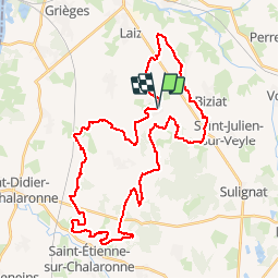
Trail Mountain bike of 44 km to be discovered at Auvergne-Rhône-Alpes, Ain, Saint-André-d'Huiriat. This trail is proposed by tracegps.

Description

Circuit avec peu de dénivelé et très roulant.

Elevation profile

Photos

Positioning

Country:
France
Region :
Auvergne-Rhône-Alpes
Department/Province :
Ain
Municipality :
Saint-André-d'Huiriat
Location:
Unknown
Start:(UTM)
647367 ; 5119480 (31T) N.

Trails nearby

Trail Horseback riding Laiz - 2023-05-25_09h39m05_boucle_30_km_vonnas-7413273-1684955259-744 - Photo
Horseback riding
azipat

Horseback riding

Difficult
Laiz, Auvergne-Rhône-Alpes, Ain, France
29 km | 33 km-effort
4h 21min
Yes
Trail Horseback riding Laiz - 2023-05-25_09h38m20_laiz_vesines_34_km-16835074-1684955197-729 - Photo
Horseback riding
azipat

Horseback riding

Difficult
(1)
Laiz, Auvergne-Rhône-Alpes, Ain, France
34 km | 38 km-effort
4h 57min
No
Trail Horseback riding Laiz - 2023-05-25_09h36m55_boucle_illiat_30km-13377883-1684955247-776 - Photo
Horseback riding
azipat

Horseback riding

Difficult
Laiz, Auvergne-Rhône-Alpes, Ain, France
29 km | 34 km-effort
4h 24min
No
Trail Walking Grièges - Griéges / Cruzille  - Photo
Walking
daniel delorme

Walking

Very easy
Grièges, Auvergne-Rhône-Alpes, Ain, France
7.2 km | 8 km-effort
1h 43min
Yes
Trail Horseback riding Laiz - Boucle Heike Vonnas - Photo
Horseback riding
poneys

Horseback riding

Difficult
Laiz, Auvergne-Rhône-Alpes, Ain, France
28 km | 31 km-effort
4h 7min
Yes
Trail Walking Illiat - Illat - Photo
Walking
janussity

Walking

Easy
Illiat, Auvergne-Rhône-Alpes, Ain, France
4.9 km | 5.7 km-effort
1h 15min
Yes
Trail Walking Saint-Jean-sur-Veyle - Saint Jean sur Veyle - Photo
Walking
chapeland

Walking

Easy
Saint-Jean-sur-Veyle, Auvergne-Rhône-Alpes, Ain, France
6.4 km | 7.1 km-effort
1h 56min
Yes
Trail Walking Perrex - Perrex  - Photo
Walking
chapeland

Walking

Medium
Perrex, Auvergne-Rhône-Alpes, Ain, France
8 km | 8.6 km-effort
2h 14min
Yes
Trail Horseback riding Laiz - Boucle Laiz 4 - Replonges - Photo
Horseback riding
poneys

Horseback riding

Difficult
Laiz, Auvergne-Rhône-Alpes, Ain, France
32 km | 35 km-effort
4h 34min
Yes


Close
My subscriptions