Trail Mountain bike Cépet - Rando des Accros 2012 - Cépet - Photo

Rando des Accros 2012 - Cépet

 tracegps
tracegps

User

© OpenStreetMap contributors
Length
Length
38 km
Max alt
Max alt
233 m
Uphill gradient
Uphill gradient
481 m
Km-Effort
Km-Effort  
44 km
Min alt
Min alt
122 m
Downhill gradient
Downhill gradient
482 m
Boucle
Boucle
Yes
Creation date :
2014-12-10 00:00:00.0
Updated on :
2014-12-10 00:00:00.0

(0 Reviews)

Mountain bike
Mountain bike
2h30
Difficulty : Difficult

Scan this QR Code to open this trail in the SityTrail application

FREE GPS app for hiking

Logo SityTrail SityTrail

IGN / Geographical institutes

Download SityTrail from the App Store Download SityTrail from Google Play

Logo SityTrail SityTrail World

The world is yours!

Download SityTrail from the App Store Download SityTrail from Google Play Download SityTrail on Huawei AppGallery

About

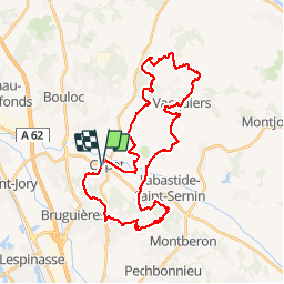
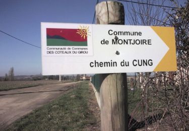
Trail Mountain bike of 38 km to be discovered at Occitania, Haute-Garonne, Cépet. This trail is proposed by tracegps.

Description

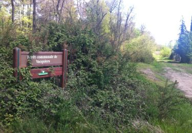
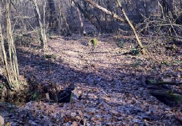
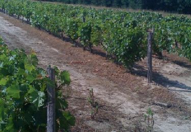
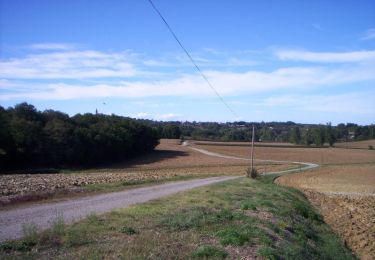
Randonnée très sympa, surtout par beau temps. On emprunte pas mal de chemins agricoles, puis on traverse les bois autour de Vacquiers, Montjoire et St Sauveur. Entre temps, on chemine dans les vignobles du Frontonnais. Pas de grosses difficultés majeures, excepté un beau raidillon au km 5,5, puis vers le km 27 (dans le bois de Montjoire) avec un poussage à la clé. De jolis singles dans ces parties boisées, où si l'on met un peu de rythme, on peu s'amuser. Quelques jolies descentes et des chemins globalement assez roulants.

Elevation profile

Positioning

Country:
France
Region :
Occitania
Department/Province :
Haute-Garonne
Municipality :
Cépet
Location:
Unknown
Start:(UTM)
373592 ; 4845278 (31T) N.

Trails nearby

Trail Walking Villariès - De Villariès à Vacquiers - Photo
Walking
tracegps

Walking

Medium
(1)
Villariès, Occitania, Haute-Garonne, France
11.5 km | 13.4 km-effort
3h 0min
Yes
Trail Mountain bike Gargas - VTT dans le Frontonnais entre Gargas, Vacquiers et Montjoire - Photo
Mountain bike
tracegps

Mountain bike

Medium
(1)
Gargas, Occitania, Haute-Garonne, France
29 km | 35 km-effort
2h 30min
Yes
Trail Running Villariès - De Villariès à Vacquiers - Photo
Running
tracegps

Running

Medium
Villariès, Occitania, Haute-Garonne, France
11.5 km | 13.4 km-effort
1h 15min
Yes
Trail Mountain bike Bouloc - Randonnée VTT entre vignes et bois de Bouloc à Fronton - Photo
Mountain bike
tracegps

Mountain bike

Medium
Bouloc, Occitania, Haute-Garonne, France
22 km | 25 km-effort
2h 0min
Yes
Trail Running Labastide-Saint-Sernin - Le Bois de Lespasié au dessus de Labastide Saint Sernin - Photo
Running
tracegps

Running

Medium
Labastide-Saint-Sernin, Occitania, Haute-Garonne, France
6.5 km | 7.5 km-effort
40min
Yes
Trail Walking Labastide-Saint-Sernin - Le Bois de Lespasié au dessus de Labastide Saint Sernin - Photo
Walking
tracegps

Walking

Medium
(1)
Labastide-Saint-Sernin, Occitania, Haute-Garonne, France
6.5 km | 7.5 km-effort
1h 49min
Yes
Trail Running Vacquiers - De Vacquiers à la Verrière - Photo
Running
tracegps

Running

Easy
Vacquiers, Occitania, Haute-Garonne, France
10.8 km | 13 km-effort
1h 0min
Yes
Trail Running Villeneuve-lès-Bouloc - Villeneuve les Bouloc Vacquiers - Photo
Running
tracegps

Running

Difficult
Villeneuve-lès-Bouloc, Occitania, Haute-Garonne, France
16.6 km | 19.4 km-effort
1h 30min
Yes
Trail Walking Villeneuve-lès-Bouloc - Villeneuve les Bouloc Vacquiers - Photo
Walking
tracegps

Walking

Medium
Villeneuve-lès-Bouloc, Occitania, Haute-Garonne, France
16.6 km | 19.4 km-effort
3h 10min
Yes


Close
My subscriptions