Trail Walking Valentine - bout du puy  - Photo
 yoyo31
yoyo31

User

© OpenStreetMap contributors
Length
Length
4.3 km
Max alt
Max alt
540 m
Uphill gradient
Uphill gradient
182 m
Km-Effort
Km-Effort  
6.8 km
Min alt
Min alt
362 m
Downhill gradient
Downhill gradient
183 m
Boucle
Boucle
Yes
Creation date :
2014-12-10 00:00:00.0
Updated on :
2014-12-10 00:00:00.0

(0 Reviews)

Walking
Walking
1h07
Difficulty : Easy

Scan this QR Code to open this trail in the SityTrail application

FREE GPS app for hiking

Logo SityTrail SityTrail

IGN / Geographical institutes

Download SityTrail from the App Store Download SityTrail from Google Play

Logo SityTrail SityTrail World

The world is yours!

Download SityTrail from the App Store Download SityTrail from Google Play Download SityTrail on Huawei AppGallery

About

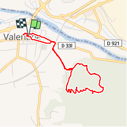
Trail Walking of 4.3 km to be discovered at Occitania, Haute-Garonne, Valentine. This trail is proposed by yoyo31.

Description

Rando courte à pies départ de Valentine pour monter au bout du puy  par les bois plutôt boisée manque de passage mes acsecible rando agréable

Elevation profile

Photos

Positioning

Country:
France
Region :
Occitania
Department/Province :
Haute-Garonne
Municipality :
Valentine
Location:
Unknown
Start:(UTM)
313264 ; 4773923 (31T) N.

Trails nearby

Trail Walking Saint-Gaudens - Via Garonna - Photo
Walking
jlmauriz

Walking

Medium
Saint-Gaudens, Occitania, Haute-Garonne, France
25 km | 30 km-effort
6h 23min
No
Trail Walking Labarthe-Rivière - Camon - Photo
Walking
jloger

Walking

Easy
Labarthe-Rivière, Occitania, Haute-Garonne, France
7.5 km | 8 km-effort
1h 40min
Yes
Trail Walking Valentine - bout du puy  - Photo
Walking
yoyo31

Walking

Easy
Valentine, Occitania, Haute-Garonne, France
4.3 km | 6.8 km-effort
1h 7min
Yes
Trail Mountain bike Encausse-les-Thermes - Espace VTT FFC Pyrénées Comminges - n° 21 Balade Encaussaise - Photo
Mountain bike
tracegps

Mountain bike

Easy
Encausse-les-Thermes, Occitania, Haute-Garonne, France
8.7 km | 9.7 km-effort
1h 0min
Yes
Trail Walking Ardiège - Ardiege, Cap de Rouzet nouveau chemin de parapente avec des gens  - Photo
Walking
Jeanne Pene

Walking

Medium
Ardiège, Occitania, Haute-Garonne, France
6.1 km | 10.6 km-effort
2h 50min
Yes
Trail Walking Ardiège - Depart Ardiege cap de la picote ,crete de Huntous,les arrousses plombières 2 le 06 Mars 2024 avec  eve - Photo
Walking
Jeanne Pene

Walking

Medium
Ardiège, Occitania, Haute-Garonne, France
9.1 km | 14.2 km-effort
3h 15min
Yes
Trail Road bike Villeneuve-de-Rivière - boucle dans le Comminges - Photo
Road bike
martoche

Road bike

Medium
Villeneuve-de-Rivière, Occitania, Haute-Garonne, France
68 km | 80 km-effort
3h 58min
No
Trail Road bike Villeneuve-de-Rivière - boucle commingeoise - Photo
Road bike
martoche

Road bike

Medium
Villeneuve-de-Rivière, Occitania, Haute-Garonne, France
61 km | 71 km-effort
3h 9min
Yes
Trail Walking Martres-de-Rivière - cap de  Rouzet en boucle depuis Martres de rivière  - Photo
Walking
GUIDE
lhomme.ph

Walking

Easy
Martres-de-Rivière, Occitania, Haute-Garonne, France
11 km | 16.2 km-effort
3h 18min
Yes


Close
My subscriptions