


Madres

xav34830
User
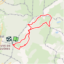

Length
15.5 km

Max alt
2466 m

Uphill gradient
910 m
Km-Effort
28 km

Min alt
1641 m

Downhill gradient
910 m
Boucle
Yes
Creation date :
2014-12-10 00:00:00.0
Updated on :
2014-12-10 00:00:00.0
--
Difficulty : Difficult

FREE GPS app for hiking
 SityTrail
IGN / Geographical institutes
SityTrail Plus
The world is yours!
About
Trail Walking of 15.5 km to be discovered at Occitania, Pyrénées-Orientales, Réal. This trail is proposed by xav34830.
Positioning
Country:
France
Region :
Occitania
Department/Province :
Pyrénées-Orientales
Municipality :
Réal
Location:
Unknown
Start:(Dec)
Start:(UTM)
430199 ; 4719265 (31T) N.
Comments