Trail Cycle Mougins - Tanneron Mandelieu bord de mer Cannes - Photo

Tanneron Mandelieu bord de mer Cannes

© OpenStreetMap contributors
Length
Length
67 km
Max alt
Max alt
471 m
Uphill gradient
Uphill gradient
1276 m
Km-Effort
Km-Effort  
84 km
Min alt
Min alt
-1 m
Downhill gradient
Downhill gradient
1276 m
Boucle
Boucle
Yes
Creation date :
2014-12-10 00:00:00.0
Updated on :
2014-12-10 00:00:00.0

(0 Reviews)

Cycle
Cycle
3h22
Difficulty : Medium

Scan this QR Code to open this trail in the SityTrail application

FREE GPS app for hiking

Logo SityTrail SityTrail

IGN / Geographical institutes

Download SityTrail from the App Store Download SityTrail from Google Play

Logo SityTrail SityTrail World

The world is yours!

Download SityTrail from the App Store Download SityTrail from Google Play Download SityTrail on Huawei AppGallery

About

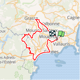
Trail Cycle of 67 km to be discovered at Provence-Alpes-Côte d'Azur, Maritime Alps, Mougins. This trail is proposed by philsutter.

Description

Au départ de Mougins le Haut en traversant la Valmasque, direction Valbonne, Plan de Grasse, Mouans-Sartoux, Pégomas puis montée du Tanneron jusqu'au Grand Duc pour redescendre sur Mandelieu pour prendre le bord de mer jusqu'à Cannes et remonter à Mougins.

Elevation profile

Positioning

Country:
France
Region :
Provence-Alpes-Côte d'Azur
Department/Province :
Maritime Alps
Municipality :
Mougins
Location:
Unknown
Start:(UTM)
341675 ; 4827802 (32T) N.

Trails nearby

Trail Cycle Cannes - st michel to funicular - Photo
Cycle
norman0000

Cycle

Very easy
(1)
Cannes, Provence-Alpes-Côte d'Azur, Maritime Alps, France
5.3 km | 7.3 km-effort
33min
Yes
Trail On foot Biot - Sentier de la Vallée de la Brague - Photo
On foot
PRO

On foot

Easy
Biot, Provence-Alpes-Côte d'Azur, Maritime Alps, France
10 km | 12.5 km-effort
2h 50min
No
Trail On foot Valbonne - Circuit des Bouillides - Photo
On foot
PRO

On foot

Easy
Valbonne, Provence-Alpes-Côte d'Azur, Maritime Alps, France
10.6 km | 13.9 km-effort
3h 8min
Yes
Trail On foot Valbonne - Circuit de l'Aqueduc - Photo
On foot
PRO

On foot

Easy
Valbonne, Provence-Alpes-Côte d'Azur, Maritime Alps, France
6.3 km | 8 km-effort
1h 49min
Yes
Trail On foot Biot - Circuit de Saint-Philippe - Photo
On foot
PRO

On foot

Easy
Biot, Provence-Alpes-Côte d'Azur, Maritime Alps, France
3.3 km | 4.7 km-effort
1h 4min
No
Trail On foot Biot - Circuit des Pierres à Four - Photo
On foot
PRO

On foot

Easy
Biot, Provence-Alpes-Côte d'Azur, Maritime Alps, France
10.3 km | 13 km-effort
2h 57min
Yes
Trail Mountain bike Valbonne - Valmasques pistes carton, Devens, des Moulins... - Photo
Mountain bike
GrouGary

Mountain bike

Easy
(2)
Valbonne, Provence-Alpes-Côte d'Azur, Maritime Alps, France
12.4 km | 15.3 km-effort
1h 53min
Yes
Trail Walking Le Cannet - Sur les pas de Bonnard, Le Cannet - Photo
Walking
GrouGary

Walking

Very easy
(1)
Le Cannet, Provence-Alpes-Côte d'Azur, Maritime Alps, France
4.8 km | 6.3 km-effort
1h 44min
Yes
Trail sport Mougins - Le long du canal de la Siagne (une partie) - Photo
sport
jwo47

sport

Very easy
Mougins, Provence-Alpes-Côte d'Azur, Maritime Alps, France
6.6 km | 7.9 km-effort
Unknown
Yes


Close
My subscriptions