


OEIL DE LA SORCIERE

patrickbeyrath
User


--
Difficulty : Medium

FREE GPS app for hiking
 SityTrail
IGN / Geographical institutes
SityTrail Plus
The world is yours!
About
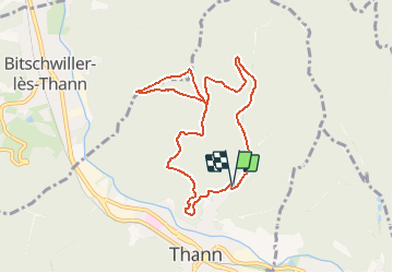
Trail Walking of 8.1 km to be discovered at Grand Est, Haut-Rhin, Thann. This trail is proposed by patrickbeyrath.
Description
Maison Forestière-rect.ROUGE direction oeil de la Sorcière-Haut du Grumbach-Col de Grumbach-Rect.Rouge blanc rouge-Belvédère Roche Albert-Grumbachkopf-Col de Grumbach et retour par Versteinerterwald-Kaltenbach
Positioning
Comments