


le Canigou depuis le col de Millères

Machaon6
User
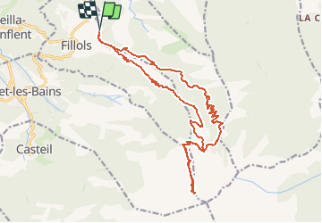

Length
22 km

Max alt
2753 m

Uphill gradient
1917 m
Km-Effort
48 km

Min alt
844 m

Downhill gradient
1922 m
Boucle
Yes
Creation date :
2014-12-10 00:00:00.0
Updated on :
2014-12-10 00:00:00.0
8h30
Difficulty : Difficult

FREE GPS app for hiking
 SityTrail
IGN / Geographical institutes
SityTrail Plus
The world is yours!
About
Trail Walking of 22 km to be discovered at Occitania, Pyrénées-Orientales, Taurinya. This trail is proposed by Machaon6.
Description
Départ col de Millères
Positioning
Country:
France
Region :
Occitania
Department/Province :
Pyrénées-Orientales
Municipality :
Taurinya
Location:
Unknown
Start:(Dec)
Start:(UTM)
452382 ; 4712753 (31T) N.
Comments
Très pratique, bien fait, le top pour randonner !