


cambre d aze vallee d eyne

xav34830
User
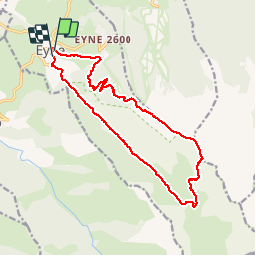

Length
19 km

Max alt
2725 m

Uphill gradient
1154 m
Km-Effort
34 km

Min alt
1583 m

Downhill gradient
1171 m
Boucle
Yes
Creation date :
2014-12-10 00:00:00.0
Updated on :
2014-12-10 00:00:00.0
8h22
Difficulty : Difficult

FREE GPS app for hiking
 SityTrail
IGN / Geographical institutes
SityTrail Plus
The world is yours!
About
Trail Walking of 19 km to be discovered at Occitania, Pyrénées-Orientales, Eyne. This trail is proposed by xav34830.
Positioning
Country:
France
Region :
Occitania
Department/Province :
Pyrénées-Orientales
Municipality :
Eyne
Location:
Unknown
Start:(Dec)
Start:(UTM)
424634 ; 4702729 (31T) N.
Comments