Trail Walking Revin - Revin: Mont Malgré Tout  - Photo

Revin: Mont Malgré Tout

 jeepee93
jeepee93

User

© OpenStreetMap contributors
Length
Length
15.1 km
Max alt
Max alt
446 m
Uphill gradient
Uphill gradient
410 m
Km-Effort
Km-Effort  
21 km
Min alt
Min alt
122 m
Downhill gradient
Downhill gradient
411 m
Boucle
Boucle
Yes
Creation date :
2014-12-10 00:00:00.0
Updated on :
2014-12-10 00:00:00.0

(0 Reviews)

Walking
Walking
4h09
Difficulty : Medium

Scan this QR Code to open this trail in the SityTrail application

FREE GPS app for hiking

Logo SityTrail SityTrail

IGN / Geographical institutes

Download SityTrail from the App Store Download SityTrail from Google Play

Logo SityTrail SityTrail World

The world is yours!

Download SityTrail from the App Store Download SityTrail from Google Play Download SityTrail on Huawei AppGallery

About

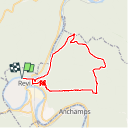
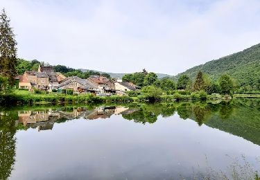
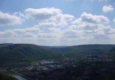
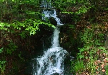
Trail Walking of 15.1 km to be discovered at Grand Est, Ardennes, Revin. This trail is proposed by jeepee93.

Description

Départ de l'office de tourisme, suivre le marquage "gros points" rouge.
Boucle dans le sens des aiguilles d'une montre.

Elevation profile

Photos

Positioning

Country:
France
Region :
Grand Est
Department/Province :
Ardennes
Municipality :
Revin
Location:
Unknown
Start:(UTM)
617306 ; 5533698 (31U) N.

Trails nearby

Trail Walking Revin - de Layfour à Anchamps - Photo
Walking
jeannine grandjean

Walking

Very difficult
Revin, Grand Est, Ardennes, France
15.2 km | 20 km-effort
4h 1min
No
Trail Walking Revin - 2022-04-25_16h18m48_SityTrail - 2733173 - revinxmalgre-tout4x2021x04x03 (1) (1) - Photo
Walking

Walking

Difficult
(1)
Revin, Grand Est, Ardennes, France
9.5 km | 12.1 km-effort
2h 44min
Yes
Trail Walking Laifour - Laifour 21,7 km - Photo
Walking
GUIDE
rvapeldo

Walking

Medium
Laifour, Grand Est, Ardennes, France
22 km | 32 km-effort
7h 15min
Yes
Trail Walking Revin - Balade à Revin - Les Bois Bryas - Photo
Walking
tracegps

Walking

Medium
Revin, Grand Est, Ardennes, France
9.2 km | 13.3 km-effort
2h 15min
Yes
Trail Mountain bike Revin - Révin - Les Bois Bryas - Ri d'Alyse et d'Oignies - Photo
Mountain bike
tracegps

Mountain bike

Difficult
Revin, Grand Est, Ardennes, France
25 km | 35 km-effort
3h 10min
Yes
Trail Mountain bike Revin - De Revin à Laifour par les Dames de Meuse - Photo
Mountain bike
tracegps

Mountain bike

Difficult
Revin, Grand Est, Ardennes, France
30 km | 41 km-effort
3h 0min
Yes
Trail Mountain bike Rocroi - Révin - Dames de Meuse - Anchamps - Photo
Mountain bike
tracegps

Mountain bike

Difficult
Rocroi, Grand Est, Ardennes, France
30 km | 39 km-effort
2h 30min
Yes
Trail Mountain bike Revin - Witaker - Bois de Hiraumont - Revin - Photo
Mountain bike
tracegps

Mountain bike

Difficult
Revin, Grand Est, Ardennes, France
27 km | 35 km-effort
2h 45min
Yes
Trail Mountain bike Revin - De Revin à Fumay par le Moulin Labotte - Photo
Mountain bike
tracegps

Mountain bike

Difficult
Revin, Grand Est, Ardennes, France
35 km | 44 km-effort
3h 0min
Yes


Close
My subscriptions