Trail Walking Larchant - 3Pi-120807 - Dene19-MtBlanc-DJouanne - Photo

3Pi-120807 - Dene19-MtBlanc-DJouanne

 randodan
randodan

User

© OpenStreetMap contributors
Length
Length
10 km
Max alt
Max alt
117 m
Uphill gradient
Uphill gradient
162 m
Km-Effort
Km-Effort  
12.2 km
Min alt
Min alt
69 m
Downhill gradient
Downhill gradient
162 m
Boucle
Boucle
Yes
Creation date :
2014-12-10 00:00:00.0
Updated on :
2014-12-10 00:00:00.0

(0 Reviews)

Walking
Walking
4h30
Difficulty : Easy

Scan this QR Code to open this trail in the SityTrail application

FREE GPS app for hiking

Logo SityTrail SityTrail

IGN / Geographical institutes

Download SityTrail from the App Store Download SityTrail from Google Play

Logo SityTrail SityTrail World

The world is yours!

Download SityTrail from the App Store Download SityTrail from Google Play Download SityTrail on Huawei AppGallery

About

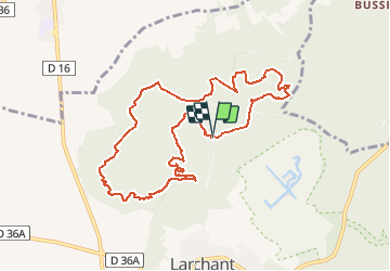
Trail Walking of 10 km to be discovered at Ile-de-France, Seine-et-Marne, Larchant. This trail is proposed by randodan.

Description

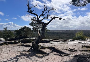
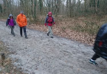
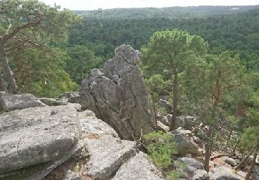
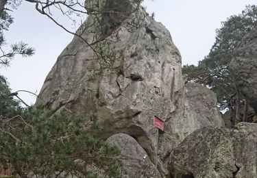
Mardi 7 août 2012. Denecourt 19 .
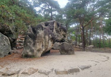
Départ parking Bois d'Hyver . Rocher de la Justice , l'Éléphant , le Auvent .
Pique-nique sur le Mont Blanc . L'ap.m. oublié relancer GPS => tracé manuel .
Hors piste vers le Cfr B.d'Hyver . Chalet Jaubert , Dame Jouanne , descente au Maunoury , retour parking 16h .
Mi Chloé Quentin Da


Elevation profile

Photos

Points of interest

Point of interest Larchant - Le Mont Blanc - Photo
randodan
LARCHANT 

Positioning

Country:
France
Region :
Ile-de-France
Department/Province :
Seine-et-Marne
Municipality :
Larchant
Location:
Unknown
Start:(UTM)
470167 ; 5349470 (31U) N.

Trails nearby

Trail On foot Larchant - Sentier Denecourt-Colinet 19 - Photo
On foot
PRO

On foot

Easy
Larchant, Ile-de-France, Seine-et-Marne, France
9.7 km | 12.3 km-effort
2h 47min
Yes
Trail Walking Villiers-sous-Grez - Villiers sous grez / Larchant - Photo
Walking
becor94

Walking

Very difficult
Villiers-sous-Grez, Ile-de-France, Seine-et-Marne, France
24 km | 29 km-effort
5h 31min
Yes
Trail Walking Larchant - Larchant la Féérique  - Photo
Walking
chessyca

Walking

Medium
Larchant, Ile-de-France, Seine-et-Marne, France
19.6 km | 24 km-effort
5h 14min
Yes
Trail Nordic walking Larchant - Dame Juane - Photo
Nordic walking
pierre_mack

Nordic walking

Larchant, Ile-de-France, Seine-et-Marne, France
22 km | 26 km-effort
3h 6min
No
Trail Walking Larchant - larchant (photo)  - Photo
Walking
Yannick89

Walking

Very easy
Larchant, Ile-de-France, Seine-et-Marne, France
15 km | 18.1 km-effort
4h 17min
Yes
Trail Walking Larchant - Larchant - Photo
Walking
gdela

Walking

Difficult
(1)
Larchant, Ile-de-France, Seine-et-Marne, France
16.6 km | 20 km-effort
4h 20min
Yes
Trail Walking Larchant - 180303 EnCours - Photo
Walking
randodan

Walking

Very easy
Larchant, Ile-de-France, Seine-et-Marne, France
9.8 km | 11.9 km-effort
3h 30min
Yes
Trail Walking Larchant - GLM-170914 - MtBlanc-DameJouanne - Photo
Walking
randodan

Walking

Easy
Larchant, Ile-de-France, Seine-et-Marne, France
10.8 km | 13.4 km-effort
4h 40min
Yes
Trail Walking Larchant - M&R-170303 - MtBlanc-DameJouanne - Photo
Walking
MarcheEtReve

Walking

Medium
Larchant, Ile-de-France, Seine-et-Marne, France
11.8 km | 14.7 km-effort
5h 0min
Yes


Close
My subscriptions