


Lavachet - Croix de Combefolle - Bois de la Laye

zgot
User
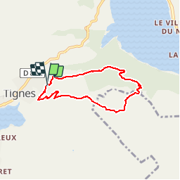

Length
5.8 km

Max alt
2278 m

Uphill gradient
322 m
Km-Effort
10.1 km

Min alt
1949 m

Downhill gradient
325 m
Boucle
Yes
Creation date :
2014-12-10 00:00:00.0
Updated on :
2014-12-10 00:00:00.0
--
Difficulty : Easy

FREE GPS app for hiking
 SityTrail
IGN / Geographical institutes
SityTrail Plus
The world is yours!
About
Trail Walking of 5.8 km to be discovered at Auvergne-Rhône-Alpes, Savoy, Tignes. This trail is proposed by zgot.
Positioning
Country:
France
Region :
Auvergne-Rhône-Alpes
Department/Province :
Savoy
Municipality :
Tignes
Location:
Unknown
Start:(Dec)
Start:(UTM)
336970 ; 5037381 (32T) N.
Comments