


Le Cuchet

prof_physique
User
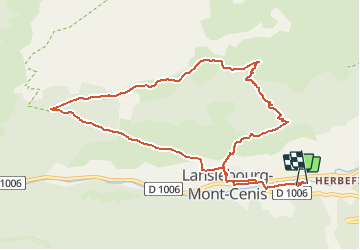

Length
11.7 km

Max alt
2088 m

Uphill gradient
733 m
Km-Effort
21 km

Min alt
1394 m

Downhill gradient
736 m
Boucle
Yes
Creation date :
2014-12-10 00:00:00.0
Updated on :
2014-12-10 00:00:00.0
--
Difficulty : Medium

FREE GPS app for hiking
 SityTrail
IGN / Geographical institutes
SityTrail Plus
The world is yours!
About
Trail Walking of 11.7 km to be discovered at Auvergne-Rhône-Alpes, Savoy, Val-Cenis. This trail is proposed by prof_physique.
Positioning
Country:
France
Region :
Auvergne-Rhône-Alpes
Department/Province :
Savoy
Municipality :
Val-Cenis
Location:
Lanslebourg-Mont-Cenis
Start:(Dec)
Start:(UTM)
334402 ; 5016802 (32T) N.
Comments