


Tulle

Geronimo2010
User
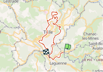

Length
16.8 km

Max alt
390 m

Uphill gradient
516 m
Km-Effort
24 km

Min alt
203 m

Downhill gradient
547 m
Boucle
No
Creation date :
2014-12-10 00:00:00.0
Updated on :
2014-12-10 00:00:00.0
--
Difficulty : Unknown

FREE GPS app for hiking
 SityTrail
IGN / Geographical institutes
SityTrail Plus
The world is yours!
About
Trail Other activity of 16.8 km to be discovered at New Aquitaine, Corrèze, Laguenne-sur-Avalouze. This trail is proposed by Geronimo2010.
Description
Tulle
Positioning
Country:
France
Region :
New Aquitaine
Department/Province :
Corrèze
Municipality :
Laguenne-sur-Avalouze
Location:
Unknown
Start:(Dec)
Start:(UTM)
405023 ; 5011424 (31T) N.
Comments