Trail Walking Sainte-Thorette - Preuilly -Ste Thorette - GR41 - Photo

Preuilly -Ste Thorette - GR41

© OpenStreetMap contributors
Length
Length
9.7 km
Max alt
Max alt
134 m
Uphill gradient
Uphill gradient
63 m
Km-Effort
Km-Effort  
10.6 km
Min alt
Min alt
109 m
Downhill gradient
Downhill gradient
74 m
Boucle
Boucle
No
Creation date :
2014-12-10 00:00:00.0
Updated on :
2014-12-10 00:00:00.0

(0 Reviews)

Walking
Walking
4h48
Difficulty : Unknown

Scan this QR Code to open this trail in the SityTrail application

FREE GPS app for hiking

Logo SityTrail SityTrail

IGN / Geographical institutes

Download SityTrail from the App Store Download SityTrail from Google Play

Logo SityTrail SityTrail World

The world is yours!

Download SityTrail from the App Store Download SityTrail from Google Play Download SityTrail on Huawei AppGallery

About

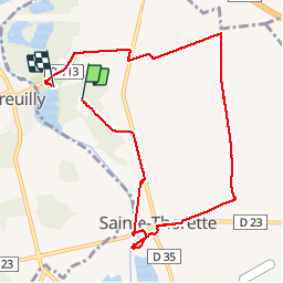
Trail Walking of 9.7 km to be discovered at Centre-Loire Valley, Cher, Sainte-Thorette. This trail is proposed by Arnoldr8491.

Description

Tour à partir du camping des Épicéas

Elevation profile

Positioning

Country:
France
Region :
Centre-Loire Valley
Department/Province :
Cher
Municipality :
Sainte-Thorette
Location:
Unknown
Start:(UTM)
438342 ; 5215980 (31T) N.

Trails nearby

Trail Other activity Mehun-sur-Yèvre - R_2 - Photo
Other activity
thyzon

Other activity

Very easy
Mehun-sur-Yèvre, Centre-Loire Valley, Cher, France
128 km | 141 km-effort
4h 1min
Yes
Trail Other activity Quincy - Descente canoë Cher  Quincy à Vierzon - Photo
Other activity
Orage

Other activity

Easy
Quincy, Centre-Loire Valley, Cher, France
15.1 km | 16.3 km-effort
2h 30min
No
Trail Other activity Quincy - MARCHE DANS LES VIGNES 6KM - Photo
Other activity
fouetillou

Other activity

Very easy
Quincy, Centre-Loire Valley, Cher, France
5.6 km | 6.1 km-effort
1h 40min
Yes


Close
My subscriptions