


64 Pierre St Martin- soum couy

trietsch
User
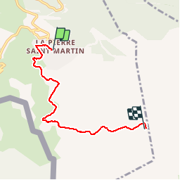

Length
5.3 km

Max alt
2142 m

Uphill gradient
508 m
Km-Effort
10.4 km

Min alt
1640 m

Downhill gradient
33 m
Boucle
No
Creation date :
2015-06-15 00:00:00.0
Updated on :
2020-01-04 20:30:55.464
3h00
Difficulty : Medium

FREE GPS app for hiking
 SityTrail
IGN / Geographical institutes
SityTrail Plus
The world is yours!
About
Trail Walking of 5.3 km to be discovered at New Aquitaine, Pyrénées-Atlantiques, Arette. This trail is proposed by trietsch.
Description
Jusqu à l arrivée du telesiege
Positioning
Country:
France
Region :
New Aquitaine
Department/Province :
Pyrénées-Atlantiques
Municipality :
Arette
Location:
Unknown
Start:(Dec)
Start:(UTM)
683882 ; 4760697 (30T) N.
Comments
très pratique