


surrier refuge bezzi

titim
User
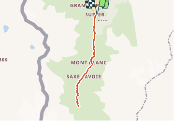

Length
12.2 km

Max alt
2281 m

Uphill gradient
524 m
Km-Effort
19.2 km

Min alt
1778 m

Downhill gradient
528 m
Boucle
Yes
Creation date :
2014-12-10 00:00:00.0
Updated on :
2014-12-10 00:00:00.0
--
Difficulty : Unknown

FREE GPS app for hiking
 SityTrail
IGN / Geographical institutes
SityTrail Plus
The world is yours!
About
Trail Walking of 12.2 km to be discovered at Aosta Valley, Unknown, Valgrisenche. This trail is proposed by titim.
Positioning
Country:
Italy
Region :
Aosta Valley
Department/Province :
Unknown
Municipality :
Valgrisenche
Location:
Unknown
Start:(Dec)
Start:(UTM)
346442 ; 5049971 (32T) N.
Comments