


col de la seigne

dominiqie
User
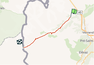

Length
15 km

Max alt
2510 m

Uphill gradient
1293 m
Km-Effort
29 km

Min alt
1495 m

Downhill gradient
286 m
Boucle
No
Creation date :
2014-12-10 00:00:00.0
Updated on :
2014-12-10 00:00:00.0
2h36
Difficulty : Unknown

FREE GPS app for hiking
 SityTrail
IGN / Geographical institutes
SityTrail Plus
The world is yours!
About
Trail Mountain bike of 15 km to be discovered at Aosta Valley, Unknown, Courmayeur. This trail is proposed by dominiqie.
Positioning
Country:
Italy
Region :
Aosta Valley
Department/Province :
Unknown
Municipality :
Courmayeur
Location:
Unknown
Start:(Dec)
Start:(UTM)
339254 ; 5074719 (32T) N.
Comments