Trail Snowshoes Formiguères - Formigueres Espousouille Fontrabiouse - Photo

Formigueres Espousouille Fontrabiouse

 xav34830
xav34830

User

© OpenStreetMap contributors
Length
Length
12.6 km
Max alt
Max alt
1657 m
Uphill gradient
Uphill gradient
432 m
Km-Effort
Km-Effort  
18.4 km
Min alt
Min alt
1492 m
Downhill gradient
Downhill gradient
432 m
Boucle
Boucle
Yes
Creation date :
2014-12-10 00:00:00.0
Updated on :
2014-12-10 00:00:00.0

(0 Reviews)

Snowshoes
Snowshoes
--
Difficulty : Medium

Scan this QR Code to open this trail in the SityTrail application

FREE GPS app for hiking

Logo SityTrail SityTrail

IGN / Geographical institutes

Download SityTrail from the App Store Download SityTrail from Google Play

Logo SityTrail SityTrail World

The world is yours!

Download SityTrail from the App Store Download SityTrail from Google Play Download SityTrail on Huawei AppGallery

About

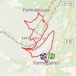
Trail Snowshoes of 12.6 km to be discovered at Occitania, Pyrénées-Orientales, Formiguères. This trail is proposed by xav34830.

Description

Excursion relativamente tranquila para ir desde Formigueres a Espousouille y a Fontrabiouse, subiendo y bajando las 2 montañas que separan estos 3 pueblos, tal como vemos en el track y en el perfil de la ruta.

Ver detalles de la excursion y fotos en nuestro blog
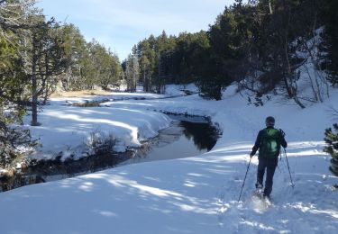
Elevation profile

Points of interest

Point of interest Fontrabiouse - Espousouille - Photo
xav34830
FONTRABIOUSE 
Point of interest Fontrabiouse - Fontrabiouse - Photo
xav34830
FONTRABIOUSE 
Point of interest Fontrabiouse - Grutas - Photo
xav34830
FONTRABIOUSE 
Point of interest Formiguères - L'Agores - Photo
xav34830
FORMIGUÈRES 
Point of interest Formiguères - Salida - Photo
xav34830
FORMIGUÈRES 

Positioning

Country:
France
Region :
Occitania
Department/Province :
Pyrénées-Orientales
Municipality :
Formiguères
Location:
Unknown
Start:(UTM)
426491 ; 4718353 (31T) N.

Trails nearby

Trail Snowshoes Réal - madres - Photo
Snowshoes
mongo

Snowshoes

Difficult
(1)
Réal, Occitania, Pyrénées-Orientales, France
13.1 km | 26 km-effort
6h 48min
Yes
Trail Walking Les Angles - les Angles - Photo
Walking
GUIDE
nadinebondoux

Walking

Difficult
Les Angles, Occitania, Pyrénées-Orientales, France
14.5 km | 20 km-effort
4h 58min
No
Trail Walking Formiguères - Les Camporells par la Lladure  - Photo
Walking
jcmartin

Walking

Medium
(1)
Formiguères, Occitania, Pyrénées-Orientales, France
15.1 km | 24 km-effort
5h 7min
Yes
Trail Walking Les Angles - boucle de la Balmette par le mont Llaret et le roc d'aude - Photo
Walking
Axelloceane

Walking

Medium
(2)
Les Angles, Occitania, Pyrénées-Orientales, France
17.2 km | 28 km-effort
Unknown
Yes
Trail Walking Puyvalador - Puyvalador tour du lac  - Photo
Walking
GUIDE
antignacs

Walking

Very easy
Puyvalador, Occitania, Pyrénées-Orientales, France
12.1 km | 15.9 km-effort
3h 39min
Yes
Trail Walking Formiguères - 20210819 Porteille d’Orlu, étang du diable - Photo
Walking
ThonyM

Walking

Difficult
Formiguères, Occitania, Pyrénées-Orientales, France
16.4 km | 29 km-effort
5h 3min
Yes
Trail Walking Formiguères - 20210710 pla del bosc - Foumigueres - Photo
Walking
ThonyM

Walking

Easy
Formiguères, Occitania, Pyrénées-Orientales, France
12.5 km | 18.3 km-effort
2h 47min
Yes
Trail Snowshoes Les Angles - 2021-02-11 Sortie CAF - Les Angles - vers les Camporells - Photo
Snowshoes
eric.mignot

Snowshoes

Medium
Les Angles, Occitania, Pyrénées-Orientales, France
16.8 km | 24 km-effort
7h 0min
Yes
Trail Snowshoes Formiguères - Formigueres el collet  - Photo
Snowshoes
GUIDE
antignacs

Snowshoes

Very easy
Formiguères, Occitania, Pyrénées-Orientales, France
6.4 km | 8.7 km-effort
2h 47min
Yes


Close
My subscriptions