


cogne lillaz cogne

titim
User
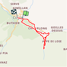

Length
13.1 km

Max alt
1725 m

Uphill gradient
384 m
Km-Effort
18.4 km

Min alt
1541 m

Downhill gradient
438 m
Boucle
No
Creation date :
2014-12-10 00:00:00.0
Updated on :
2014-12-10 00:00:00.0
4h19
Difficulty : Unknown

FREE GPS app for hiking
 SityTrail
IGN / Geographical institutes
SityTrail Plus
The world is yours!
About
Trail Walking of 13.1 km to be discovered at Aosta Valley, Unknown, Cogne. This trail is proposed by titim.
Photos


Positioning
Country:
Italy
Region :
Aosta Valley
Department/Province :
Unknown
Municipality :
Cogne
Location:
Unknown
Start:(Dec)
Start:(UTM)
372251 ; 5051696 (32T) N.
Comments