Trail Walking Saint-Héand - tour de st heand - Photo
© OpenStreetMap contributors
Length
Length
13.2 km
Max alt
Max alt
751 m
Uphill gradient
Uphill gradient
380 m
Km-Effort
Km-Effort  
18.3 km
Min alt
Min alt
476 m
Downhill gradient
Downhill gradient
379 m
Boucle
Boucle
Yes
Creation date :
2014-12-10 00:00:00.0
Updated on :
2014-12-10 00:00:00.0

(0 Reviews)

Walking
Walking
3h15
Difficulty : Very easy

Scan this QR Code to open this trail in the SityTrail application

FREE GPS app for hiking

Logo SityTrail SityTrail

IGN / Geographical institutes

Download SityTrail from the App Store Download SityTrail from Google Play

Logo SityTrail SityTrail World

The world is yours!

Download SityTrail from the App Store Download SityTrail from Google Play Download SityTrail on Huawei AppGallery

About

Trail Walking of 13.2 km to be discovered at Auvergne-Rhône-Alpes, Loire, Saint-Héand. This trail is proposed by acsglaurent.

Description


    le départ et le retour ce font aux parking du plan d'eau    

Elevation profile

Photos

Points of interest

Point of interest Saint-Héand - Point 5 - Photo
acsglaurent
SAINT-HÉAND 
Point of interest Saint-Héand - parking plan d'eau - Photo
acsglaurent
SAINT-HÉAND 

Positioning

Country:
France
Region :
Auvergne-Rhône-Alpes
Department/Province :
Loire
Municipality :
Saint-Héand
Location:
Unknown
Start:(UTM)
607501 ; 5043741 (31T) N.

Trails nearby

Trail Walking Saint-Héand - St Heand, Montrond, Mont Morin, Pierre de la Bauche et retour St Heand - Photo
Walking
acsglaurent

Walking

Medium
(1)
Saint-Héand, Auvergne-Rhône-Alpes, Loire, France
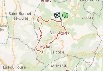
16 km | 23 km-effort
5h 20min
Yes
Trail Walking Sorbiers - sorbiers 23/2 - Photo
Walking
stefp42

Walking

Difficult
(1)
Sorbiers, Auvergne-Rhône-Alpes, Loire, France
23 km | 35 km-effort
4h 36min
Yes
Trail Walking Sorbiers - sorbiers - Photo
Walking
stefp42

Walking

Difficult
(1)
Sorbiers, Auvergne-Rhône-Alpes, Loire, France
23 km | 36 km-effort
4h 46min
Yes
Trail Walking Sorbiers - sorbiers-st christo - valfeury  - Photo
Walking
stefp42

Walking

Medium
(1)
Sorbiers, Auvergne-Rhône-Alpes, Loire, France
23 km | 35 km-effort
4h 32min
Yes
Trail Walking Saint-Héand - izzy - Photo
Walking
bena42

Walking

Easy
Saint-Héand, Auvergne-Rhône-Alpes, Loire, France
5.9 km | 8.1 km-effort
1h 10min
Yes
Trail Walking Saint-Héand - Saint-héand, la pierre de la bauche, les alisiers, le rivollier, les baraques, Saint-héand - Photo
Walking
nollac

Walking

Medium
Saint-Héand, Auvergne-Rhône-Alpes, Loire, France
12.3 km | 17.8 km-effort
2h 53min
Yes
Trail Walking Saint-Bonnet-les-Oules - Saint-Bonnet-les-Oules du 26-12-2022 - Photo
Walking
VANDERPUTTENMi

Walking

Difficult
Saint-Bonnet-les-Oules, Auvergne-Rhône-Alpes, Loire, France
10.8 km | 14.5 km-effort
2h 17min
Yes
Trail Mountain bike Fontanès - la fouillouse antenne Aveizieux  - Photo
Mountain bike
bena42

Mountain bike

Difficult
Fontanès, Auvergne-Rhône-Alpes, Loire, France
11.3 km | 14.3 km-effort
4h 9min
No
Trail Walking Chambœuf - début balade Chamboeuf la combe - Photo
Walking
Cécile M.

Walking

Medium
Chambœuf, Auvergne-Rhône-Alpes, Loire, France
7 km | 9.3 km-effort
1h 26min
No


Close
My subscriptions