Trail Walking Saint-Héand - Saint-héand, la pierre de la bauche, les alisiers, le rivollier, les baraques, Saint-héand - Photo

Saint-héand, la pierre de la bauche, les alisiers, le rivollier, les baraques, Saint-héand

 nollac
nollac

User

© OpenStreetMap contributors
Length
Length
12.3 km
Max alt
Max alt
873 m
Uphill gradient
Uphill gradient
414 m
Km-Effort
Km-Effort  
17.8 km
Min alt
Min alt
671 m
Downhill gradient
Downhill gradient
412 m
Boucle
Boucle
Yes
Creation date :
2023-02-09 13:02:51.164
Updated on :
2023-02-09 17:38:01.914

(0 Reviews)

Walking
Walking
2h53
Difficulty : Medium

Scan this QR Code to open this trail in the SityTrail application

FREE GPS app for hiking

Logo SityTrail SityTrail

IGN / Geographical institutes

Download SityTrail from the App Store Download SityTrail from Google Play

Logo SityTrail SityTrail World

The world is yours!

Download SityTrail from the App Store Download SityTrail from Google Play Download SityTrail on Huawei AppGallery

About

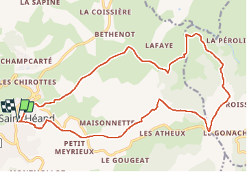
Trail Walking of 12.3 km to be discovered at Auvergne-Rhône-Alpes, Loire, Saint-Héand. This trail is proposed by nollac.

Description

Circuit en boucle.
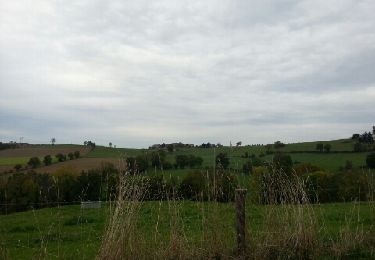
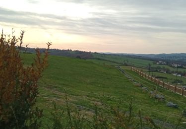
Rando agréable avec de beaux chemins, des traversées de magnifiques sous bois et quelques montées assez raides !
Le temps indiqués comportent quelques petits arrêts boisson-collation.

Elevation profile

Photos

Positioning

Country:
France
Region :
Auvergne-Rhône-Alpes
Department/Province :
Loire
Municipality :
Saint-Héand
Location:
Unknown
Start:(UTM)
607217 ; 5042642 (31T) N.

Trails nearby

Trail Walking Saint-Héand - St Heand, Montrond, Mont Morin, Pierre de la Bauche et retour St Heand - Photo
Walking
acsglaurent

Walking

Medium
(1)
Saint-Héand, Auvergne-Rhône-Alpes, Loire, France
16 km | 23 km-effort
5h 20min
Yes
Trail Walking La Fouillouse - Randonnée au dessus de La Fouillouse  - Photo
Walking
dudu42

Walking

Medium
La Fouillouse, Auvergne-Rhône-Alpes, Loire, France
14.6 km | 19.9 km-effort
3h 39min
Yes
Trail Walking Sorbiers - sorbiers 23/2 - Photo
Walking
stefp42

Walking

Difficult
(1)
Sorbiers, Auvergne-Rhône-Alpes, Loire, France
23 km | 35 km-effort
4h 36min
Yes
Trail Walking Sorbiers - sorbiers - Photo
Walking
stefp42

Walking

Difficult
(1)
Sorbiers, Auvergne-Rhône-Alpes, Loire, France
23 km | 36 km-effort
4h 46min
Yes
Trail Walking Sorbiers - sorbiers-st christo - valfeury  - Photo
Walking
stefp42

Walking

Medium
(1)
Sorbiers, Auvergne-Rhône-Alpes, Loire, France
23 km | 35 km-effort
4h 32min
Yes
Trail Mountain bike L'Étrat - 16ème Randonnée Le Terrassou (2013-VTT-60km) - L'Étrat - Photo
Mountain bike
tracegps

Mountain bike

Very difficult
L'Étrat, Auvergne-Rhône-Alpes, Loire, France
60 km | 84 km-effort
5h 30min
Yes
Trail Walking Saint-Héand - izzy - Photo
Walking
bena42

Walking

Easy
Saint-Héand, Auvergne-Rhône-Alpes, Loire, France
5.9 km | 8.1 km-effort
1h 10min
Yes
Trail Walking Saint-Héand - tour de st heand - Photo
Walking
acsglaurent

Walking

Very easy
Saint-Héand, Auvergne-Rhône-Alpes, Loire, France
13.2 km | 18.3 km-effort
3h 15min
Yes
Trail Walking Saint-Bonnet-les-Oules - Saint-Bonnet-les-Oules du 26-12-2022 - Photo
Walking
VANDERPUTTENMi

Walking

Difficult
Saint-Bonnet-les-Oules, Auvergne-Rhône-Alpes, Loire, France
10.8 km | 14.5 km-effort
2h 17min
Yes


Close
My subscriptions