


Menhir Langenstein

regisbodilis
User
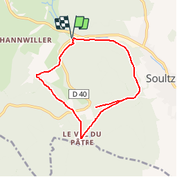

Length
7 km

Max alt
400 m

Uphill gradient
149 m
Km-Effort
9 km

Min alt
306 m

Downhill gradient
151 m
Boucle
Yes
Creation date :
2014-12-10 00:00:00.0
Updated on :
2014-12-10 00:00:00.0
3h00
Difficulty : Easy

FREE GPS app for hiking
 SityTrail
IGN / Geographical institutes
SityTrail Plus
The world is yours!
About
Trail Walking of 7 km to be discovered at Grand Est, Haut-Rhin, Soultzmatt. This trail is proposed by regisbodilis.
Description
Le tour du Pfingsberg - Soultzmatt
Positioning
Country:
France
Region :
Grand Est
Department/Province :
Haut-Rhin
Municipality :
Soultzmatt
Location:
Unknown
Start:(Dec)
Start:(UTM)
366701 ; 5314360 (32T) N.
Comments