Trail Mountain bike Champagnac-de-Belair - Tour de Champagnac - Photo
 ilplane
ilplane

User

© OpenStreetMap contributors
Length
Length
27 km
Max alt
Max alt
212 m
Uphill gradient
Uphill gradient
395 m
Km-Effort
Km-Effort  
32 km
Min alt
Min alt
109 m
Downhill gradient
Downhill gradient
394 m
Boucle
Boucle
Yes
Creation date :
2014-12-10 00:00:00.0
Updated on :
2014-12-10 00:00:00.0

(0 Reviews)

Mountain bike
Mountain bike
1h43
Difficulty : Medium

Scan this QR Code to open this trail in the SityTrail application

FREE GPS app for hiking

Logo SityTrail SityTrail

IGN / Geographical institutes

Download SityTrail from the App Store Download SityTrail from Google Play

Logo SityTrail SityTrail World

The world is yours!

Download SityTrail from the App Store Download SityTrail from Google Play Download SityTrail on Huawei AppGallery

About

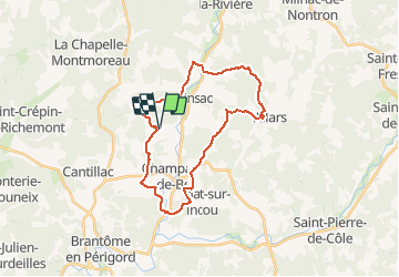
Trail Mountain bike of 27 km to be discovered at New Aquitaine, Dordogne, Champagnac-de-Belair. This trail is proposed by ilplane.

Description

Route et chemins autour de Champagnac.
On passe par St Pancrace, Quinsac et Villars. Beaucoup de variantes possibles pour faire plus court ou plus long.
Attention aux épines du côté de Maletière.
Bonne balade!
         

Elevation profile

Positioning

Country:
France
Region :
New Aquitaine
Department/Province :
Dordogne
Municipality :
Champagnac-de-Belair
Location:
Unknown
Start:(UTM)
318982 ; 5031648 (31T) N.

Trails nearby

Trail Walking Champagnac-de-Belair - Boucle de Champagnac de bel air - Photo
Walking
Patricew

Walking

Difficult
Champagnac-de-Belair, New Aquitaine, Dordogne, France
12.7 km | 15.7 km-effort
3h 33min
Yes
Trail Walking Saint-Pancrace - Boucle de St Pancrace 24 - Photo
Walking
swp648

Walking

Easy
Saint-Pancrace, New Aquitaine, Dordogne, France
12.6 km | 15.4 km-effort
3h 51min
Yes
Trail Mountain bike Villars - Mareuil Pauliac Brantôme Pressillac - Photo
Mountain bike
charrier

Mountain bike

Medium
Villars, New Aquitaine, Dordogne, France
109 km | 136 km-effort
8h 23min
Yes
Trail Walking Condat-sur-Trincou - Condat-sur-Trincou Dronne Trincou 13km - Photo
Walking
YV24

Walking

Easy
Condat-sur-Trincou, New Aquitaine, Dordogne, France
12.6 km | 15.8 km-effort
3h 26min
Yes
Trail Walking Champagnac-de-Belair - Champagnac Belair Drone Trincou - Photo
Walking
YV24

Walking

Easy
Champagnac-de-Belair, New Aquitaine, Dordogne, France
13.4 km | 16.7 km-effort
3h 36min
Yes
Trail Walking La Chapelle-Faucher - La Chapelle-Faucher - Photo
Walking
swp648

Walking

Medium
La Chapelle-Faucher, New Aquitaine, Dordogne, France
12.2 km | 15.2 km-effort
3h 19min
Yes
Trail Walking Champagnac-de-Belair - bOUCLE cHAMPAGNAC DE BELAIR 27 KM - Photo
Walking
Melifera

Walking

Very difficult
Champagnac-de-Belair, New Aquitaine, Dordogne, France
27 km | 33 km-effort
7h 26min
Yes
Trail Walking La Chapelle-Faucher - Boucle-De-La-Chapelle-Faucher-INSEE-24107 - Photo
Walking
Melifera

Walking

Difficult
La Chapelle-Faucher, New Aquitaine, Dordogne, France
14.7 km | 18.7 km-effort
3h 11min
Yes
Trail Walking Saint-Pancrace - Boucle-De-St-Pancrace-INSEE-24474 - Photo
Walking
Melifera

Walking

Easy
Saint-Pancrace, New Aquitaine, Dordogne, France
12.3 km | 15.1 km-effort
3h 0min
Yes


Close
My subscriptions