


Vallée de la Wormsa

bob68
User
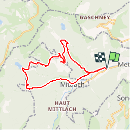

Length
15.2 km

Max alt
1082 m

Uphill gradient
672 m
Km-Effort
24 km

Min alt
491 m

Downhill gradient
671 m
Boucle
Yes
Creation date :
2014-12-10 00:00:00.0
Updated on :
2014-12-10 00:00:00.0
5h00
Difficulty : Difficult

FREE GPS app for hiking
 SityTrail
IGN / Geographical institutes
SityTrail Plus
The world is yours!
About
Trail Walking of 15.2 km to be discovered at Grand Est, Haut-Rhin, Metzeral. This trail is proposed by bob68.
Description
Depuis Metzéral, Lac du Fischboedle, lac Altenweiher, Kolbenwasen
Positioning
Country:
France
Region :
Grand Est
Department/Province :
Haut-Rhin
Municipality :
Metzeral
Location:
Unknown
Start:(Dec)
Start:(UTM)
354936 ; 5319347 (32U) N.
Comments