


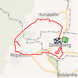
Zellemberg vignoble

bob68
User

Length
8.7 km

Max alt
381 m

Uphill gradient
195 m
Km-Effort
11.3 km

Min alt
249 m

Downhill gradient
201 m
Boucle
Yes
Creation date :
2014-12-10 00:00:00.0
Updated on :
2014-12-10 00:00:00.0
2h00
Difficulty : Easy

FREE GPS app for hiking
 SityTrail
IGN / Geographical institutes
SityTrail Plus
The world is yours!
About
Trail Walking of 8.7 km to be discovered at Grand Est, Haut-Rhin, Zellenberg. This trail is proposed by bob68.
Positioning
Country:
France
Region :
Grand Est
Department/Province :
Haut-Rhin
Municipality :
Zellenberg
Location:
Unknown
Start:(Dec)
Start:(UTM)
375147 ; 5336457 (32U) N.
Comments