Trail Walking Montvalent - Causse toujours - Photo

Causse toujours

 sdroneau
sdroneau

User

© OpenStreetMap contributors
Length
Length
17.2 km
Max alt
Max alt
285 m
Uphill gradient
Uphill gradient
433 m
Km-Effort
Km-Effort  
23 km
Min alt
Min alt
104 m
Downhill gradient
Downhill gradient
434 m
Boucle
Boucle
Yes
Creation date :
2014-12-10 00:00:00.0
Updated on :
2014-12-10 00:00:00.0

(0 Reviews)

Walking
Walking
4h30
Difficulty : Difficult

Scan this QR Code to open this trail in the SityTrail application

FREE GPS app for hiking

Logo SityTrail SityTrail

IGN / Geographical institutes

Download SityTrail from the App Store Download SityTrail from Google Play

Logo SityTrail SityTrail World

The world is yours!

Download SityTrail from the App Store Download SityTrail from Google Play Download SityTrail on Huawei AppGallery

About

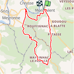
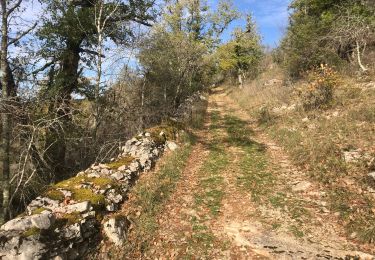
Trail Walking of 17.2 km to be discovered at Occitania, Lot, Montvalent. This trail is proposed by sdroneau.

Description

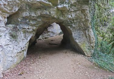
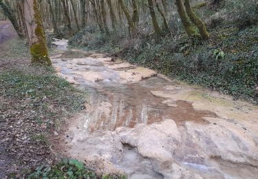
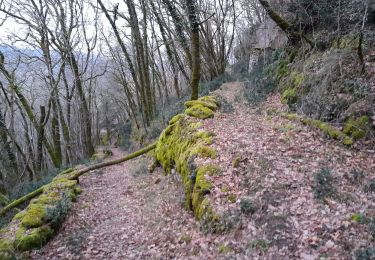
Ballade entre Causse et Dordogne au départ de Montvalent. Au programme : chemins rocailleux, fontaines, résurgence et un magnifique point de vue dans la dernière montée (difficile) sur la vallée de la Dordogne. Bonne ballade.

Elevation profile

Photos

Points of interest

Point of interest Rocamadour - Source      - Photo
sdroneau
ROCAMADOUR 
Point of interest Rocamadour - montée de l'échine de l'ane - Photo
sdroneau
Point of interest Montvalent - Montée du causse - Photo
sdroneau
MONTVALENT 
Point of interest Montvalent - Point de vue Dordogne - Photo
sdroneau
Point of interest Montvalent - Point de vue - Photo
sdroneau
MONTVALENT 

Positioning

Country:
France
Region :
Occitania
Department/Province :
Lot
Municipality :
Montvalent
Location:
Unknown
Start:(Dec)
Start:(UTM)
390794 ; 4970671 (31T) N.

Trails nearby

Trail Walking Saint-Sozy - St-Sozy  - Photo
Walking
tracegps

Walking

Medium
(5)
Saint-Sozy, Occitania, Lot, France
8 km | 12 km-effort
2h 0min
Yes
Trail Walking Montvalent - Montvalent - Photo
Walking
Gpoujade

Walking

Medium
(1)
Montvalent, Occitania, Lot, France
13.7 km | 17.9 km-effort
3h 49min
Yes
Trail On foot Lacave - Gouffre et résurgence du Limon - Grottes de Lacave - Photo
On foot
PRO

On foot

Easy
Lacave, Occitania, Lot, France
14.4 km | 19.6 km-effort
4h 26min
Yes
Trail Walking Saint-Sozy - Saint Sozy -  - Photo
Walking
houbart

Walking

Very difficult
Saint-Sozy, Occitania, Lot, France
13.8 km | 20 km-effort
4h 15min
Yes
Trail Walking Floirac - autour de Floirac  - Photo
Walking
bellouelo46

Walking

Very easy
Floirac, Occitania, Lot, France
16.5 km | 22 km-effort
4h 7min
Yes
Trail Walking Floirac - le caillon cirque de foirac  - Photo
Walking
bellouelo46

Walking

Very easy
Floirac, Occitania, Lot, France
13.5 km | 18.8 km-effort
3h 13min
Yes
Trail Walking Montvalent - Bendou - Photo
Walking
Gaillard Isabelle

Walking

Easy
Montvalent, Occitania, Lot, France
15.6 km | 21 km-effort
3h 38min
Yes
Trail Mountain bike Floirac - Boucle Floirac - Montvalent par Le Pech Cayrou et Roque De Cor - Photo
Mountain bike
Gpoujade

Mountain bike

Easy
Floirac, Occitania, Lot, France
30 km | 38 km-effort
18min
Yes
Trail Walking Floirac - Floirac - Photo
Walking
Gaillard Isabelle

Walking

Easy
Floirac, Occitania, Lot, France
15.1 km | 19.5 km-effort
3h 49min
Yes


Close
My subscriptions