


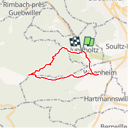
Jungholtz-Croix Zimmermann-Wuenheim

patrickbeyrath
User


3h00
Difficulty : Medium

FREE GPS app for hiking
 SityTrail
IGN / Geographical institutes
SityTrail Plus
The world is yours!
About
Trail Walking of 9.7 km to be discovered at Grand Est, Haut-Rhin, Jungholtz. This trail is proposed by patrickbeyrath.
Description
Départ près de la rue St Anne, Triangle jaune, à Ste Anne, prendre Rond Jaune jusqu'à la Croix Zimmermann-puis Triangle Rouge direction La Sapinière et Wuenheim,Repas au Restaurant de la Couronne et retour par le chemin et Croix Bleu
Positioning
Comments