


Tignes - Val Claret - Lac de Chevril

ballet
User
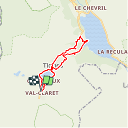

Length
11.2 km

Max alt
2136 m

Uphill gradient
460 m
Km-Effort
17.3 km

Min alt
1719 m

Downhill gradient
460 m
Boucle
Yes
Creation date :
2014-12-10 00:00:00.0
Updated on :
2014-12-10 00:00:00.0
3h20
Difficulty : Medium

FREE GPS app for hiking
 SityTrail
IGN / Geographical institutes
SityTrail Plus
The world is yours!
About
Trail Walking of 11.2 km to be discovered at Auvergne-Rhône-Alpes, Savoy, Tignes. This trail is proposed by ballet.


Positioning
Country:
France
Region :
Auvergne-Rhône-Alpes
Department/Province :
Savoy
Municipality :
Tignes
Location:
Unknown
Start:(Dec)
Start:(UTM)
335812 ; 5035874 (32T) N.
Comments