


--Pont-du-Casse-- OR-947025:boucle pont du casse - sympa

mapomme
User
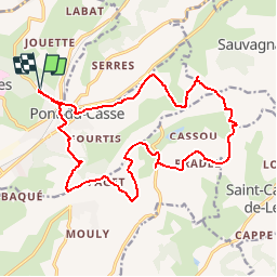

Length
20 km

Max alt
188 m

Uphill gradient
379 m
Km-Effort
25 km

Min alt
63 m

Downhill gradient
375 m
Boucle
Yes
Creation date :
2014-12-10 00:00:00.0
Updated on :
2014-12-10 00:00:00.0
--
Difficulty : Unknown

FREE GPS app for hiking
 SityTrail
IGN / Geographical institutes
SityTrail Plus
The world is yours!
About
Trail Other activity of 20 km to be discovered at New Aquitaine, Lot-et-Garonne, Pont-du-Casse. This trail is proposed by mapomme.


Positioning
Country:
France
Region :
New Aquitaine
Department/Province :
Lot-et-Garonne
Municipality :
Pont-du-Casse
Location:
Unknown
Start:(Dec)
Start:(UTM)
313978 ; 4900921 (31T) N.
Comments