


boucle pont du casse - figue

mapomme
User
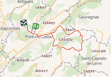

Length
15.3 km

Max alt
192 m

Uphill gradient
302 m
Km-Effort
19.3 km

Min alt
64 m

Downhill gradient
291 m
Boucle
No
Creation date :
2014-12-10 00:00:00.0
Updated on :
2014-12-10 00:00:00.0
1h38
Difficulty : Very easy

FREE GPS app for hiking
 SityTrail
IGN / Geographical institutes
SityTrail Plus
The world is yours!
About
Trail Mountain bike of 15.3 km to be discovered at New Aquitaine, Lot-et-Garonne, Pont-du-Casse. This trail is proposed by mapomme.
Description
Petite boucle d'hiver : plus de goudron que d'habitude ... Mais encore bcp de chemins gras. Aucune diff technique.
Positioning
Country:
France
Region :
New Aquitaine
Department/Province :
Lot-et-Garonne
Municipality :
Pont-du-Casse
Location:
Unknown
Start:(Dec)
Start:(UTM)
314285 ; 4900614 (31T) N.
Comments