


2013-04-21 Rando CVA Dordogne

holtzv
User GUIDE
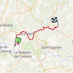

Length
36 km

Max alt
230 m

Uphill gradient
758 m
Km-Effort
45 km

Min alt
46 m

Downhill gradient
630 m
Boucle
No
Creation date :
2014-12-10 00:00:00.0
Updated on :
2014-12-10 00:00:00.0
5h40
Difficulty : Medium

FREE GPS app for hiking
 SityTrail
IGN / Geographical institutes
SityTrail Plus
The world is yours!
About
Trail Equestrian of 36 km to be discovered at New Aquitaine, Dordogne, Alles-sur-Dordogne. This trail is proposed by holtzv.
Description
Départ : La Haute Yerle
Arrivée : Auberge la Taulado

Positioning
Country:
France
Region :
New Aquitaine
Department/Province :
Dordogne
Municipality :
Alles-sur-Dordogne
Location:
Unknown
Start:(Dec)
Start:(UTM)
331591 ; 4971051 (31T) N.
Comments